Overview
Kampala faces a documented set of natural and urban hazards — storms, lightning, flooding, soil erosion, and building collapse — that affect its five administrative divisions with different intensities. The most comprehensive assessment remains the Kampala Multi-Hazard Risk and Vulnerability Profile, published in August 2018 by the Kampala Capital City Authority (KCCA), which analysed risk across the entire city using satellite data, field surveys, and community focus groups.
Understanding these hazards is relevant to anyone living in, working in, or passing through the capital. During multiple visits to Uganda — including transit through Kampala in October 2024 and again in January 2026 and May 2026 — what stands out about the city is not simply its energy but the density and complexity of its built environment. A city that generates 65 per cent of Uganda's national GDP (source: Kampala Multi-Hazard Risk and Vulnerability Profile, August 2018) and accommodates a population growing at approximately 2.02 per cent per year (source: Uganda Bureau of Statistics, as cited in the 2018 profile) is a city under pressure on every surface — its roads, its hillside settlements, its drainage systems, and its buildings.
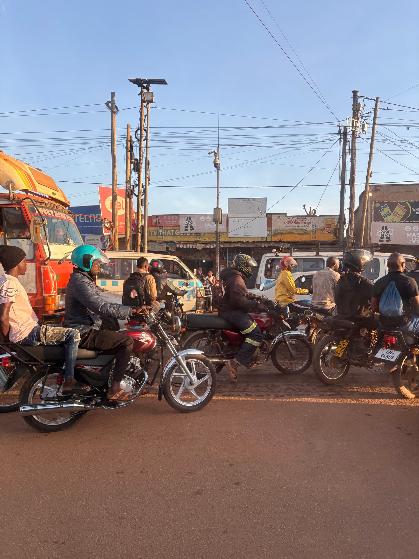
Passing through Kampala in May 2026, arriving directly from Entebbe International Airport, the first impression is of a city in permanent motion. Bodaboda motorcycles, bicycles, private cars, and shared minibuses cross and merge at intersections without apparent hierarchy. The roadside from the airport through the city's central core is uninterrupted commerce — fuel stations, food stalls, mobile phone outlets, hardware shops. The photograph I took at GPS coordinates 0.2917°N, 32.4996°E that morning captures precisely this: a mass of vehicles and people navigating a shared space according to an informal logic that functions, mostly, but leaves little margin.
Kampala: A Capital Built on Hills and Wetlands
Kampala is traditionally described as a city built on seven hills, spreading outward from the original Mengo hill settlement of the Buganda Kingdom. In practice, the contemporary city occupies considerably more terrain than that original description implies — a dense, multi-layered urban area that expanded rapidly after receiving municipal status in 1947 and accelerated further after Ugandan independence in 1962, when Kampala formally became the national capital.
The city is administered through five divisions. Kawempe occupies the north; Makindye — the second-largest division with an area of approximately 39 square kilometres (source: 2018 Multi-Hazard Risk and Vulnerability Profile) — lies to the south; Nakawa covers the east; Lubaga the west; and Kampala Central sits in the middle, entirely surrounded by the other four divisions. The boundaries of these divisions correspond, roughly, to the topographic features of the city — hilltops hosting planned settlements, valleys and wetlands filled over decades with informal housing and industrial land use.
The wetlands are central to understanding Kampala's vulnerability. The natural drainage system of the city was designed by the terrain — rainwater from the hills flowed into the valley bottoms and from there into Murchison Bay on the northern shore of Lake Victoria. As the city grew, these valleys were progressively built over. The consequence is visible during every heavy rainfall: water that once moved freely through natural channels now accumulates against buildings, roads, and informal structures built in its path.
The Uganda National Museum sits 3 kilometres from Kampala's city centre along Kiira Road (source: 2018 Multi-Hazard Risk and Vulnerability Profile) — a useful landmark for orientating oneself in the city's northern zone. The Kasubi Tombs, a UNESCO World Heritage Site and burial place of four Buganda kings, occupy a hill in the Lubaga Division. Both sites represent the historical and cultural depth of a city that predates colonial settlement by many centuries.
The Hazard Profile: What the Risk Matrix Shows
The 2018 Multi-Hazard Risk and Vulnerability Profile assessed Kampala across more than a dozen natural and human-influenced hazards, rating each on probability and severity. The methodology drew on GIS analysis, satellite imagery from USGS (covering 2005 and 2016 land-use changes), and structured community consultations — focus group discussions conducted in all five divisions: Central, Nakawa, Makindye, Lubaga, and Kawempe.
The following table summarises the key hazard ratings from the 2018 risk matrix. All ratings should be understood as reflecting conditions at the time of the assessment and may have changed as the city has continued to grow.
| Hazard | Risk Rating | Notes |
|---|---|---|
| Storms (wind, hail) | Medium | Affects all five divisions; 45.5% of city area exposed to light wind events under 10-year return period |
| Lightning | Medium | Elevated incidence near Murchison Bay during rainy seasons; convective thunderstorms over Lake Victoria |
| Flooding | High (local) | Valley and wetland areas; flood hazard data modelled using KCCA, Uganda National Meteorological Authority and Directorate of Water Resources Management data |
| Soil erosion | Medium | Assessed via 7-factor spatial model: lithology, soil type, depth, rainfall, slope, land cover, road proximity |
| Building collapse | Medium–High | Particularly in Kawempe Division; not confined to a single area — city-wide risk |
| Traffic accidents | High (Kawempe) | Probability 3 (high), severity 2 (medium); Bombo Road through Bwaise is a specific risk corridor |
| Land conflicts | Medium | Probability 2 (medium), severity 2 (medium); areas including Katwe and Kibuye |
| Plant pests and diseases | Low | Lower priority relative to other urban hazards |
Source for all ratings: Kampala Multi-Hazard Risk and Vulnerability Profile, August 2018 (KCCA). Note: these ratings reflect 2018 assessment methodology and should be verified against more recent KCCA publications before use in formal planning contexts.
Storm and Wind Risk: Understanding the Numbers
The storm hazard analysis in the 2018 profile categorised Kampala's wind exposure by wind speed class, using a 10-year return period as the analytical baseline. 45.5 per cent of Kampala's total land area is affected by light winds of 2.7 to 3.6 metres per second — classified as a light breeze on the Beaufort scale. A further 24 per cent of the city's area is exposed to moderate winds of 7.2 to 8 metres per second, the threshold at which roof materials can be displaced and tree branches broken (source: Kampala Multi-Hazard Risk and Vulnerability Profile, August 2018).
The storm hazard is rated medium across the city. This classification is significant not because individual storm events in Kampala are unusual — they are not — but because the combination of dense informal housing, corrugated iron roofing materials, and inadequate building standards amplifies the structural impact of moderate wind events. A storm that would cause limited damage to a well-constructed building can strip the roof of a makeshift structure entirely.
Lightning Near Murchison Bay
Lightning risk in Kampala is closely associated with the city's position on the northern shore of Lake Victoria. Murchison Bay, the sheltered inlet of the lake adjacent to Kampala's southern edge, generates convective weather activity during the two rainy seasons (March–May and October–November). Warm, moisture-laden air rising from the lake surface produces the cumulonimbus cloud formations that are the immediate precursor to lightning events.
The 2018 profile identifies enhanced lightning occurrence near Murchison Bay during these rainy periods. For residents and visitors in Kampala's southern divisions — particularly Makindye and the lower-lying parts of Kampala Central — this means that standard lightning safety practices are relevant: avoiding open elevated ground, staying clear of isolated tall trees, and sheltering in substantial buildings rather than temporary structures during active thunderstorms. The risk is predictable by season; it is the infrastructure that determines whether that risk translates into harm.
Building Safety: Collapse Risk Across the City
Building collapse is rated medium to high risk in Kampala, with Kawempe Division in the north cited as a particular area of concern (source: 2018 Multi-Hazard Risk and Vulnerability Profile, August 2018). Critically, the profile notes that building collapse is not confined to a single district — it can occur across the entire city, reflecting the widespread presence of structures built without formal engineering oversight.
The seismic component adds a further dimension. The 2018 profile's seismic hazard analysis found peak ground acceleration (PGA) values reaching 0.05 to 0.1 g in the western areas of Lubaga Division and extending into Kampala Central — the highest values in the city (source: 2018 Multi-Hazard Risk and Vulnerability Profile). A PGA threshold of 0.092 g marks the boundary between zones of moderate and very low hazard in the Kampala analysis. While these values are low by global seismic standards, they are not negligible in a context where many structures lack reinforcement designed to absorb lateral ground movement.
The practical implication is straightforward: buildings matter. The material from which a structure is built, how its foundations relate to the hillside topography, and whether it occupies a natural drainage line are all factors that determine its vulnerability to the compound effects of storm, water, seismic movement, and soil erosion acting simultaneously or in sequence.
Soil Erosion on Kampala's Slopes
Soil erosion is rated medium risk across Kampala and is concentrated on slopes with gradients of 20 per cent or more, which the 2018 profile identifies as zones of higher natural hazard probability (source: Kampala Multi-Hazard Risk and Vulnerability Profile, August 2018). The assessment used a seven-factor spatial model — evaluating lithology, soil type, soil depth, rainfall intensity, slope gradient, land cover, and proximity to roads — to produce a spatially explicit erosion hazard map.
On Kampala's hills, the removal of tree cover for agricultural and residential use has reduced the root binding that holds topsoil in place. Combined with the high rainfall intensities of the two wet seasons, this creates conditions for active surface erosion, particularly on exposed cut slopes created by road construction or building terracing. Erosion is not a dramatic sudden hazard like flooding, but its cumulative effect on slope stability and on the silting of drainage channels is material to the city's long-term flood risk.
Traffic: Kampala's Highest-Visibility Urban Hazard
Of all the hazards documented in the 2018 profile, road traffic accidents are among the most visible and statistically significant. In Kawempe Division, traffic accidents receive the highest probability rating in the risk matrix — score 3 (high) — combined with a medium severity score of 2 (source: 2018 Multi-Hazard Risk and Vulnerability Profile). The Bombo Road corridor through the Bwaise area is specifically identified as a high-risk route, consistent with the volume and mix of traffic that uses it daily.
Traffic regulation in Kampala is the joint responsibility of the Kampala Capital City Authority (KCCA) and the Uganda Police Force. The 2018 profile identifies traffic monitoring and enforcement as the primary institutional mitigation strategy. In practice, the enforcement capacity is real but intermittent — particularly at peak hours and on secondary routes where traffic exceeds the design capacity of the road surface.
The bodaboda — motorcycle taxi — is the element of Kampala's traffic that most consistently surprises first-time visitors. During our October 2024 transit through Jinja, Mark Suer and a companion took a bodaboda ride organised through the Butiru Freundeskreis network. Three people on one motorcycle, no helmets, light shoes, navigating the main street. This is not an extreme event in Uganda; it is an ordinary one. In the same visit, we photographed a bodaboda rider on a rural road outside Kampala carrying multiple large water jerry cans — no rack, no restraint beyond balance. The utility and the risk coexist, and neither cancels the other.
The boda boda's role in urban accident statistics is well-established. The 2018 profile identifies boda bodas alongside minibuses and private cars as the principal vehicle types involved in Kampala's road accidents. The mitigation strategies recorded in the profile include community-level accident mapping, which engaged residents across all five divisions in identifying specific locations and types of road hazard — a participatory approach that produced more granular spatial data than traffic agency records alone could provide.
What This Means for Visitors and Long-Term Residents
The hazard profile assembled by KCCA in 2018 was produced primarily as a planning document — to inform infrastructure investment, emergency preparedness, and urban development decisions. For visitors and residents, the practical implications translate into a shorter list of considerations.
During the rainy seasons (March–May, October–November), low-lying areas of the city — particularly in the valley zones of Makindye, parts of Lubaga, and Kawempe — are susceptible to localised flooding. Water accumulation on roads can be significant within minutes of heavy rainfall. Routes that are navigable in dry conditions may require diversion. Checking road conditions before travelling through the city in the wet season is straightforward with local knowledge; asking a hotel, driver, or guesthouse is more reliable than relying on navigation apps that do not account for surface water.
For storm events: corrugated iron roofing, which covers the majority of buildings in Kampala's informal and semi-formal residential areas, is vulnerable to uplift in moderate wind events. During storms, remaining inside a substantial building and away from windows is the standard precaution. Temporary roadside structures — market stalls, informal workshops — offer no meaningful protection during significant rainfall or wind.
For building safety: the medium-to-high building collapse rating in the 2018 profile reflects the cumulative effect of construction without formal oversight. This is a structural reality of the built environment rather than an acute threat to visitors in established hotels or guesthouses. The risk is distributed across the city's informally built residential stock.
For those arriving from Entebbe and transiting through Kampala — whether heading west toward Fort Portal and Kasese, or north toward Murchison Falls — understanding the city's traffic rhythm is the most immediately relevant safety consideration. The Kampala to western Uganda road guide covers the practical logistics of navigating out of the capital on the main road corridors.
[QUOTE: local resident or KCCA official on community-level preparedness and adaptation strategies in Kampala — to be collected on next visit]
Community Adaptation and Institutional Response
The 2018 profile documents that communities across Kampala's five divisions have developed multiple adaptation strategies in response to natural hazards — approaches focused on damage mitigation and incremental resilience building. This reflects a long-standing reality: formal early warning systems and emergency response infrastructure in Kampala have lagged behind the pace of urban growth, and residents have adapted accordingly.
The flood hazard modelling component of the 2018 profile required coordinated data collection from three institutions: the Directorate of Water Resources Management, the Uganda National Meteorological Authority, and the KCCA itself — covering land use, geomorphology, and rainfall records respectively. The integration of these datasets represents a more sophisticated approach to urban hazard assessment than had previously been conducted in Kampala, and its output provided, for the first time, a spatially explicit picture of flood risk down to division level.
The storm hazard component of the same profile recommended daily monitoring of wind speed and humidity as a minimum standard for operational early warning. As of the 2018 assessment, this level of monitoring was not consistently in place. The recommendation implies a gap between the hazard data available and the institutional capacity to act on it in real time — a common challenge in rapidly urbanising African cities, and one that Kampala shares with many of its regional peers.
This context matters for visitors planning extended stays in Kampala. Connections to local networks — tour operators, guesthouses, community organisations — provide better real-time hazard awareness than any formal system. The community tourism approach documented in Buhoma illustrates how local knowledge networks function as practical resilience infrastructure — a principle that applies equally in Kampala's urban setting.
From the field
Frequently asked questions
What natural hazards affect Kampala, Uganda?
Kampala is exposed to multiple natural and urban hazards, including storms with hail and strong winds (rated medium risk), lightning strikes concentrated near Murchison Bay during the rainy seasons, flooding in low-lying wetland areas, soil erosion on steep slopes (rated medium risk), and building collapse (rated medium to high risk, particularly in Kawempe Division). These findings come from the Kampala Capital City Authority's Multi-Hazard Risk and Vulnerability Profile, published in August 2018. The ratings reflect conditions at the time of the 2018 assessment and should be verified against current KCCA data for formal planning use.
Which parts of Kampala are most at risk from storms?
According to the Kampala Multi-Hazard Risk and Vulnerability Profile (August 2018), 45.5 per cent of Kampala's land area is affected by light winds of 2.7 to 3.6 metres per second under a 10-year return period analysis, while 24 per cent of the city is exposed to moderate winds of 7.2 to 8 metres per second. The storm hazard analysis was conducted across all five administrative divisions: Central, Nakawa, Makindye, Lubaga, and Kawempe. Informal housing with corrugated iron roofing is most vulnerable to moderate storm events.
Is Kampala at risk from earthquakes?
Kampala faces a low to moderate seismic hazard. The seismic hazard analysis in the 2018 Multi-Hazard Risk and Vulnerability Profile identified peak ground acceleration (PGA) values of up to 0.092 g in the western parts of the city — particularly in Lubaga Division extending toward Kampala Central — representing the highest-risk zones for seismic ground motion. While this level of seismic activity is low by global standards, it is a relevant factor for buildings constructed without formal engineering oversight, which make up a significant proportion of Kampala's built environment.
How dangerous is traffic in Kampala?
Road accidents are among the highest-rated urban hazards in Kampala. The 2018 Multi-Hazard Risk and Vulnerability Profile rates traffic accidents in Kawempe Division at high probability (score 3) and medium severity (score 2), with the Bombo Road through Bwaise identified as a specific high-risk corridor. Bodaboda motorcycles, minibuses, and private vehicles are the main transport types involved in urban incidents. Traffic control is the joint responsibility of the Kampala Capital City Authority and the Uganda Police Force, with community mapping used to identify local accident hotspots.
What is the rainy season in Kampala and how does it affect safety?
Kampala has two rainy seasons: the long rains from March to May and a shorter wet period from October to November. During these periods, storm risk increases significantly, flooding in low-lying wetland areas and drainage channels becomes common, and lightning activity intensifies near Murchison Bay on Lake Victoria's northern shore. The Uganda National Meteorological Authority monitors weather conditions in coordination with KCCA, though the 2018 Hazard Profile explicitly recommends daily monitoring of wind and humidity data as an improvement to the existing early warning infrastructure.