Overview
The road from Kampala to Fort Portal in western Uganda is 300 kilometres of continuously paved highway, passable in 4 to 6 hours by car and served daily by several bus operators. The route west is the main artery connecting Uganda's capital to the Rwenzori foothills, Queen Elizabeth National Park, Kasese, and the highland towns that serve as gateways to Bwindi Impenetrable National Park further south.
Somewhere between the organised chaos of Kampala's streets and the first open stretch of road beyond Mityana, Uganda reveals itself. During my visit in October 2024 — four days travelling west and north from Kampala, GPS-documented at multiple stops — what stayed with me was not the distance or the road quality but the texture of the journey itself: what you see on the roadside, who shares the road with you, and what that tells you about how Uganda moves.
Starting Point: Getting Out of Kampala
Kampala, Uganda's capital, is divided into five administrative divisions: Kawempe in the north, Makindye in the south, Nakawa in the east, Lubaga in the west, and Kampala Central — which is entirely surrounded by the other four divisions (source: Kampala Multi-Hazard Risk and Vulnerability Profile, August 2018). The city sprawls across a series of hills and valleys, and navigating it by vehicle requires patience rather than speed.
Most long-distance journeys into western Uganda begin either from Entebbe International Airport, which lies 35 kilometres south of Kampala, or from one of the city's main bus terminals near the Old Taxi Park in Kampala Central. If you are arriving by air and heading straight west, your driver will route you through central Kampala — there is no practical bypass that avoids the city entirely for the Fort Portal road.
After we were collected at Entebbe in January 2026, we drove directly through Kampala. The city was exactly as I had experienced it in October 2024: full, layered, and relentlessly in motion. Bodaboda motorcycles, minibuses, and private cars occupy every lane simultaneously. The roadside from the airport junction through to the city's western exits is lined with small businesses, fuel stations, roadside vendors, and the dense commercial activity that characterises Uganda's urban economy. This is not a city you pass through unnoticed — it is a city that asks you to slow down and look.
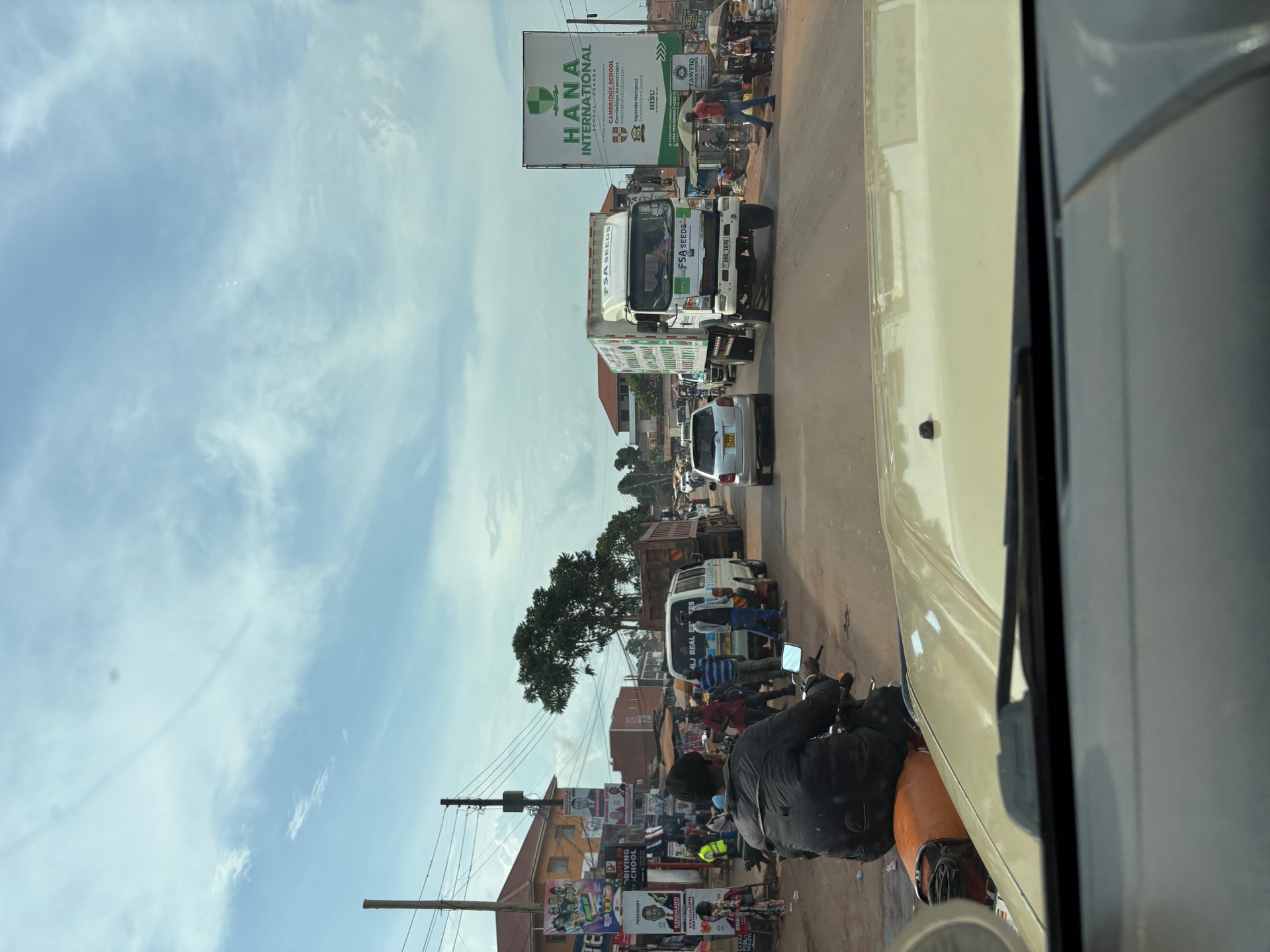
Kampala's average annual temperature ranges from a minimum of approximately 16.2°C to a maximum of around 28.7°C (source: Kampala Multi-Hazard Risk and Vulnerability Profile, August 2018), making it comfortable for travel in all seasons. Heavy rainfall — particularly during the two rainy seasons (March–May and October–November) — can cause significant traffic disruption in the city's lower-lying areas, where natural drainage into the wetlands that dot the urban landscape becomes overwhelmed.
Kampala to Fort Portal: 300 Kilometres West
The road west from Kampala toward Fort Portal follows the A109 through Mityana and Mubende before climbing toward the Rwenzori foothills. The entire 300-kilometre route is paved. Road quality is generally reliable, with the stretch around Mubende — a busy trucking corridor connecting Kampala with Congo border towns — occasionally slow due to heavy goods vehicles.
Mityana: First Major Town, 82 Kilometres
Mityana is the first significant urban stop after Kampala, approximately 82 kilometres from the city centre. The town sits on a hillside and is a useful point to stop for fuel, food, and toilet facilities. The roadside markets here are active from early morning, selling fresh produce, cooked food, and household goods from small, permanent stalls. Journey time from Kampala to Mityana varies considerably depending on traffic leaving the capital — in clear conditions, 1.5 hours; in peak-hour congestion, closer to 2.5 hours.
Mubende: Midpoint and Regional Hub, 150 Kilometres
Mubende sits roughly at the halfway point of the Kampala–Fort Portal route, approximately 150 kilometres from Kampala. It is a regional administrative centre with a more developed service infrastructure than smaller roadside towns — you will find fuel, restaurants, guesthouses, and mobile money services here. The Nakayima Tree, a large fig tree associated with the Baganda royal tradition, is a well-known landmark on the hill above the town and a point of historical significance that many travellers stop to view.
Fort Portal: Gateway to the West, 300 Kilometres
Fort Portal in the Tooro Kingdom area of western Uganda is one of the most appealing of Uganda's secondary cities. It sits at approximately 1,500 metres altitude with clear views of the Rwenzori Mountains on good days, and serves as the base for access to Kibale National Park (chimpanzee trekking, 26 kilometres to the south-east), the crater lakes region, and Queen Elizabeth National Park to the south. The town has a manageable centre, reliable accommodation across budget ranges, and a well-supplied market.
Journey time from Kampala to Fort Portal is 4 to 6 hours by private car and 6 to 7 hours by bus, depending on the number of stops. Bus services depart from Kampala's Old Taxi Park area, with Link Bus and Kalita Bus among the operators running daily services. Book the previous evening if possible, particularly at weekends.
Fort Portal to Kasese: The Final 80 Kilometres South
From Fort Portal, the road south to Kasese covers approximately 80 kilometres, adding around 1.5 to 2 hours to the western route. The total distance from Kampala to Kasese is therefore close to 400 kilometres — a journey of 5 to 6 hours by private vehicle or 7 to 8 hours by bus. The road is paved throughout.
Kasese is the principal town of the Kasese District and the main access point for the southern sectors of Queen Elizabeth National Park, which stretches between Lake George and Lake Edward. It also functions as a transit point for travellers heading further south toward Kabale and the gorilla trekking sectors of Bwindi Impenetrable National Park — though the mountain road from Kasese to Kabale is long and should not be underestimated in terms of time.
For visitors continuing to southwest Uganda and Bwindi, the road from Kasese runs south through Bushenyi and then southeast to Kabale — the nearest large town to the Bwindi gorilla trekking sectors. The complete gorilla trekking guide for Bwindi covers permit logistics, sector choices, and what to expect on the trek itself.
The Northern Alternative: Kampala to Murchison Falls
The road to Murchison Falls National Park takes a fundamentally different direction from the western Fort Portal route. Rather than heading west, the Murchison road goes north-west from Kampala toward Masindi, approximately 215 kilometres from the capital — a drive of 3 to 4 hours on paved road. From Masindi, the route continues north and west into the park, with the final stretch on unpaved road.
It was on the approach to Murchison Falls, on the road from the Masindi area heading north-west toward the park boundary, that I witnessed one of the more memorable scenes of the October 2024 trip. A small minibus had been loaded with cargo to a height more than double the vehicle itself — mattresses, foam rolls, household goods of various kinds, all roped and stacked into a tower that gave the bus the proportions of a moving wardrobe. The driver continued at a steady pace on the well-surfaced road, entirely unbothered. This is not unusual in Uganda; it is the normal operating logic of a transport system where capacity and resourcefulness are the same thing.
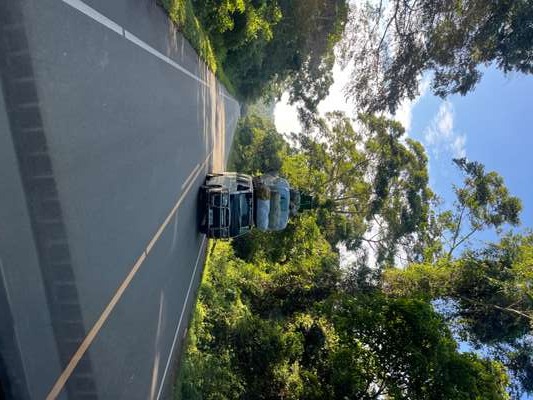
This GPS coordinate — 1.9624°N, 31.7122°E — places the photograph on the approach road to Murchison Falls, in the central-northern corridor between Masindi and the park's southern boundary. The road here is paved and in generally good condition. The surrounding landscape at this point opens out from the densely cultivated land south of Masindi into wider, flatter terrain that signals the transition toward the park's savannah and riverine vegetation.
Masindi: The Gateway Town for Murchison Falls
Masindi is the practical base for Murchison Falls visits originating from Kampala. The town has fuel, accommodation at several price points, and reliable mobile network coverage — the last reliable fuelling point before the park entrance. Beyond the Kichumbanyobo gate, the road into the park becomes unpaved and requires significantly more time per kilometre. The southern bank of the park, which includes the famous boat trip to the base of Murchison Falls and the ferry crossing at Paraa, is accessed via this southern route.
During our Murchison boat trip in October 2024, the river banks produced consistent wildlife sightings. We observed Nile crocodiles — some at considerable distance from the boat, yet still visibly large — resting on the banks at GPS coordinates 2.2771°N, 31.6698°E. The scale and stillness of a large crocodile at rest is genuinely arresting even from a moving boat. Further upstream near GPS 2.2853°N, 31.5099°E, a bull elephant moved unhurried through the grassland parallel to the river, his tusks white against the grey of the dry-season vegetation.
What Moves on Uganda's Roads: Transport Culture
Understanding Uganda's road culture is practical knowledge, not merely local colour. The roads between Kampala and the national parks are shared by a mix of private cars, minibuses (taxis in Ugandan usage, though they function as shared buses on fixed routes), large goods lorries, pedestrians, and boda bodas — the motorcycle taxis that function as the country's most versatile and ubiquitous transport system.
On the road outside Masindi in October 2024, I photographed a boda boda rider carrying a full complement of large jerry cans — water canisters bound together on the rear rack, several more balanced forward. No helmet, sandals on both feet, proceeding at a reliable pace. This is not an exceptional image in Uganda. It is the boda boda operating as it does throughout the country: as the last-mile solution for goods that no lorry will carry and no taxi will take. The versatility is genuine and the informality is structural — this is how water reaches homes in areas without piped supply.
Accident rates involving boda bodas have increased in recent years in Kampala and on major routes, according to the Kampala Multi-Hazard Risk and Vulnerability Profile (August 2018), which identifies boda bodas, taxis, and private vehicles as the most frequent transport types involved in urban road incidents. Travellers sharing the road — particularly on the busier sections between Kampala and Mubende — should account for unpredictable overtaking and the physical presence of motorcycle traffic at every junction and roadside stop.
Natural Hazards and Road Safety on the Western Corridor
Uganda's geography creates specific road hazards that are worth understanding before departure. The Kampala Multi-Hazard Risk and Vulnerability Profile (August 2018), commissioned by Kampala Capital City Authority, identified several physical risk factors relevant to travel planning.
Areas of Kampala with slopes of 20 per cent or more show a higher probability of natural hazard events, including landslides during heavy rainfall. The western route out of Kampala initially crosses relatively flat terrain but rises significantly before Fort Portal, passing through hillier country in the Mubende and Kyenjojo districts. During the main rainy seasons — March to May and October to November — sections of road in elevated terrain can be affected by surface water and occasional debris from steeper ground.
The storm hazard analysis for Kampala conducted for the 2018 profile found that 45.5 per cent of Kampala's area is exposed to light winds of 2.7 to 3.6 m/s under a 10-year return period analysis, while 24 per cent of the city's area is affected by more substantial winds of 7.2 to 8 m/s. The profile's recommendations explicitly call for daily monitoring of wind and humidity conditions to improve early warning capacity — a gap that remains relevant in 2026, particularly for the period approaching and during the rainy seasons.
For practical road travel, the implications are straightforward: the dry seasons (June to August, December to February) offer consistently better road conditions on all routes. Travelling west to Fort Portal in June or July provides the most predictable road surface. If you are planning a visit to Murchison Falls, October — while technically a transitional season — was dry enough during our 2024 visit to cause no road problems on the Masindi approach; the park roads themselves become increasingly difficult in heavy rain.
Emily Assimwe, who runs a store in Buhoma in southwest Uganda and has received western travellers for years, echoes a view common among those who know the roads: the route matters less than the timing. The same road that is straightforward in July becomes a different proposition in April.
Practical Logistics: Transport Options Compared
Private Car or Hired Driver
The most comfortable and time-efficient option for the Kampala–Fort Portal route is a private vehicle. Most tour operators and guesthouses in Kampala can arrange a driver and 4x4 or saloon car. Rates vary significantly — budget for 150,000 to 250,000 UGX per day for a basic vehicle plus driver, more for a 4x4 with camping gear. A hired driver also provides local knowledge of stopping points and can adapt the route to individual interests, including informal stops at markets, viewpoints, or roadside attractions.
Public Bus
Public bus services cover the Kampala–Fort Portal route daily. Operators including Link Bus, Kalita Bus, and Gateway depart from the Old Taxi Park area in Kampala Central and from Kisenyi, typically in the morning. The journey takes 6 to 7 hours with stops, tickets are sold at the bus park or from operators' offices the evening before, and fares are substantially lower than a private hire. Buses are the standard choice for Ugandan travellers and for budget visitors; they are functional but make multiple stops and are not air-conditioned on most routes.
Shared Taxi (Minibus)
Shared minibuses operate between major towns on most routes, departing when full rather than on a fixed schedule. They are cheaper than buses on a per-seat basis but less predictable in timing. For the Kampala–Fort Portal route, a shared taxi will typically change at Mubende. This mode of transport is how the overloaded minibus I photographed near Murchison Falls was operating — carrying goods and passengers simultaneously, maximising every journey.
From the field
Frequently asked questions
How far is it from Kampala to Fort Portal?
Fort Portal lies approximately 300 kilometres west of Kampala on a continuously paved road. The journey takes between 4 and 6 hours depending on traffic leaving Kampala and road conditions around Mubende. Direct buses depart daily from Kampala's Kisenyi and Old Taxi Park area. Most travellers find 5 hours a realistic estimate for a private car with one stop.
How long does it take to drive from Kampala to Murchison Falls?
Murchison Falls National Park is most commonly reached via Masindi, roughly 215 kilometres north-west of Kampala — a drive of 3 to 4 hours on paved road. From Masindi to the southern boundary of the park adds a further 80 kilometres, with the final stretch on unpaved road. Allow a full day if you want to reach the park in time for an evening game drive. The northern circuit of the park requires crossing the Nile at Paraa by vehicle ferry.
What bus companies operate from Kampala to Fort Portal?
Several companies operate daily services from Kampala to Fort Portal, departing from the Old Taxi Park and the Kisenyi area. Link Bus, Kalita Bus, and Gateway Bus all cover this route regularly. Tickets are best booked the evening before to guarantee a seat, particularly at weekends and around public holidays. The journey time by bus is typically 6 to 7 hours with stops.
Is the road from Kampala to Fort Portal paved?
Yes. The A109 from Kampala through Mityana and Mubende to Fort Portal is fully paved for its entire 300-kilometre length. Road quality is generally reliable, with the Mubende section carrying significant truck traffic that can cause delays. The road from Fort Portal to Kasese is also tarmac throughout. Beyond Fort Portal into the national park areas, road conditions depend on the specific route and the season.
How do I get from Entebbe Airport to Fort Portal?
Entebbe International Airport lies 35 kilometres south of Kampala. Most travellers are collected at the airport by their tour operator or driver and continue to Fort Portal on the same day without an overnight stop in Kampala. If using public transport, you first need to reach Kampala by taxi or boda boda from Entebbe, then travel from the city's western bus terminals onward. Allow the better part of a day for the full Entebbe-to-Fort Portal journey by public transport.