Overview
Kabale is the practical hub for gorilla trekking in Uganda. Sitting at roughly 1,870 metres above sea level in the far southwest of the country, it houses the Uganda Wildlife Authority permit office, connects to every Bwindi sector within three hours by road, and offers accommodation for every budget — from a USD 5 hostel bed to a 24-room hotel with a swimming pool. Most gorilla trekkers pass through Kabale; the ones who treat it as more than a transit stop tend to enjoy their journey more.
Getting to southwestern Uganda from elsewhere in the country means spending real time on the road. On the drive from Butiru toward Murchison Falls in October 2024, we passed a minibus with a cargo load twice the height of the vehicle itself — mattresses, rolled textiles, household goods stacked and roped to the roof rack in an architecture that would alarm any road safety inspector and impress any logistics engineer. The driver had clearly done this before. So had every other road user, who gave the overloaded vehicle a wide berth without breaking pace.
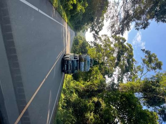
This image captures something genuine about moving around Uganda. The country has invested substantially in its trunk road network — the paved highway connecting Kampala to Mbarara to Kabale is largely in good condition — but logistics in the interior operate on a different logic. Goods move when and how they can, in whatever vehicle is available, loaded to whatever capacity the road and gravity will allow. It is functional, occasionally spectacular, and completely unremarkable to anyone who has driven in Uganda more than once.
I have made this journey, and variations of it, across five separate visits to Uganda between 2024 and 2026 — including a stay in October 2024 near Murchison Falls (GPS-tagged at 2.2771°N, 31.6698°E on the boat safari) and gorilla trekking near Bwindi in January 2026. Understanding how Ugandan road travel works — and what Kabale offers as a base — changes how you plan the entire southwest itinerary.
Kabale: Character, Elevation, and Why It Matters
Kabale is the administrative capital of the Kabale District, situated in Uganda's extreme southwest between the borders with Rwanda and the Democratic Republic of Congo. The elevation — nearly 1,870 metres — gives it a climate unlike most of Uganda. Nights are genuinely cold by equatorial standards, sometimes dropping to around 10°C. Days are warm but rarely hot. The air feels different from Kampala or Entebbe: clearer, cooler, with the sharp quality of highland East Africa.
The landscape around Kabale is terraced. The Bakiga people — the dominant ethnic group in this highland region — have farmed the steep hillsides for generations using bench terracing to prevent erosion and maintain soil productivity. From a hillside vantage point, the view across these terraced slopes, interspersed with banana plantations and occasional patches of natural forest remnants, is one of the most visually distinctive in Uganda.
The town itself is compact. The commercial centre concentrates around the main market and bus park, with a short walk between most essential services — banks, the main market, the bus park, and the residential neighbourhoods on the surrounding hills. The African College of Commerce and the Great Lakes Institute are both located in or near Kabale, giving the town a student population and educational infrastructure unusual for a provincial centre of its size.
Getting to Kabale
From Kampala, the standard route is southwest on the Kampala–Masaka–Mbarara highway, then continuing to Kabale — a total distance of around 420 kilometres and a driving time of six to eight hours depending on traffic out of Kampala and road conditions. Several coach companies operate daily departures from Kampala's long-distance bus parks; journey times are typically seven to eight hours. The road is largely paved and in reasonable condition.
From Kigali in Rwanda, the crossing at Katuna (on the Ugandan side) or Gatuna (on the Rwandan side) is the primary border point. Kabale is around 15 kilometres from this crossing — approximately 20 to 30 minutes by road. Many travellers doing a Rwanda–Uganda circuit arrive or depart via this crossing, making Kabale effectively the first or last Ugandan city they encounter.
Where to Stay in Kabale
Kabale's accommodation market is better developed than its size might suggest, largely because the gorilla trekking industry has driven demand for a full range of options — from international travellers with large permit budgets who need a comfortable pre-trek base, to overland backpackers keeping costs minimal.
Budget Options
Kabale Backpackers is one of the best-known hostels in southwest Uganda. Run by Lilian Kamusime — also the deputy chair of the Uganda Safari Guides Association — the hostel is centrally located, with single rooms from USD 9 and doubles from USD 15. What makes it unusually trustworthy as a recommendation is its transparency: the Kabale Backpackers donates ten percent of its revenues to the Rumbugu Primary School, a commitment that is stated publicly and maintained consistently. The hostel also serves as an informal information hub for Bwindi logistics.
Kwanzi Hostel is the budget alternative, offering single rooms from USD 5 and doubles from USD 10. Its primary attraction beyond price is the restaurant, called The Nest, which sits on a high point of the property with a view over the rooftops of Kabale toward the surrounding hills. Ruth, who runs Kwanzi, has built a reputation for practical hospitality — she arranges canoe trips on Lake Bunyonyi for guests, handles transport logistics, and maintains a small display about the culture and history of the Bakiga people. The hostel also runs a souvenir shop that sells goods from the Grace Villa orphan project.
Mid-Range and Above
The Green Hills Hotel on Makanga Hill is Kabale's most established accommodation option. With 24 rooms, a swimming pool, a restaurant, and a location adjacent to the UWA gorilla permit office, it occupies a position that is simultaneously the most practical and the most historically embedded in the tourism infrastructure of the town. Travellers who book their permit in advance and arrive the night before their trek stay here without needing to organise separate transport to the permit office.
| Property | Type | From (single / double) | Key feature |
|---|---|---|---|
| Kwanzi Hostel | Budget | USD 5 / USD 10 | Rooftop restaurant, canoe trip arrangements, Bakiga culture display |
| Kabale Backpackers | Budget–mid | USD 9 / USD 15 | 10% revenue to local school; run by Safari Guides Association deputy chair |
| Green Hills Hotel | Mid-range | On request | 24 rooms, pool, restaurant, adjacent to UWA permit office |
Organising Gorilla Trekking from Kabale
The most important practical reason to stay in Kabale before gorilla trekking is the UWA permit office. Located on Makanga Hill directly beside the Green Hills Hotel, it is the primary in-country purchase point for gorilla trekking permits. Most international travellers book online through the Uganda Wildlife Authority website before arriving in Uganda — which is the recommended approach — but the Kabale office handles in-person queries, day-of availability checks, and permit collection for those who booked through a tour operator and need to pick up physical documentation.
Permit prices in 2026 are USD 800 per person in the main season and USD 450 during the low season months of April, May, and November. These permit prices are set by the Uganda Wildlife Authority and are identical regardless of where the permit is purchased or through which operator. The price includes park entry, guide, and armed ranger accompaniment for the one-hour encounter with a gorilla family. Transport to and from the trailhead, accommodation, and tips are not included.
Uganda's mountain gorilla population — counted at 459 individuals across the 2018–2020 census period — is split between two parks: Bwindi Impenetrable National Park and Mgahinga Gorilla National Park. Bwindi has the larger number of habituated families and therefore more permit slots per day. Mgahinga has a single habituated family — the Nyakagezi group — which means fewer permits but a less crowded experience.
Which Bwindi Sector and Transfer Times from Kabale
Bwindi has four main tracking sectors: Buhoma in the north, Ruhija in the northeast, and Rushaga and Nkuringo in the south. Each has different gorilla families, different terrain difficulty levels, and different drive times from Kabale.
- Rushaga (south Bwindi): approximately 1.5 to 2 hours from Kabale — the closest sector, making it the most common choice for travellers based in Kabale.
- Nkuringo (southwest Bwindi): approximately 2 hours from Kabale; the Nkuringo Bwindi Gorilla Lodge sits at 2,090 metres elevation at the trailhead.
- Ruhija (northeast Bwindi): approximately 2.5 hours; the Ruhija Gorilla Safari Lodge provides accommodation directly near the tracking point.
- Buhoma (north Bwindi): approximately 3 hours from Kabale; historically the first sector opened for tourism and still the most internationally recognised.
The drive from Kabale to the Rushaga or Nkuringo sector is practical as a same-day transfer on the morning of a trek. For Buhoma, most travellers arrive the previous day and stay in or near the sector — the road is longer and lodge accommodation near the trailhead offers an early start without a three-hour predawn drive.
[QUOTE: Kabale permit office staff on same-day availability for last-minute permits, especially in the low season]
Lake Bunyonyi: Thirty Minutes from Kabale
Lake Bunyonyi is around 30 kilometres west of Kabale — a short drive that delivers a completely different landscape. The lake sits at roughly 1,962 metres elevation, surrounded by steep terraced hills that descend directly to the water. The name translates approximately as "place of many little birds" in Rukiga, referencing the lake's reputation for birdlife — over 200 species have been recorded in the area.
The lake contains 29 islands, most of them small and uninhabited. Several carry lodges or community guesthouses accessible only by dugout canoe or motorboat. Bwama Island is the most historically significant: in 1921, the Scottish physician and missionary Leonard Sharp established a hospital for leprosy patients there, creating one of the first dedicated treatment facilities for the disease in the region. At its peak, the facility treated around 5,000 patients. Modern leprosy treatment made the hospital largely redundant by the 1980s, and Bwama Island today is a school site — the hospital structures remain, and Sharp's original residence became part of the Sharp Island Gorilla Lodge on the adjacent Njuyeera Island.
The lake is considered safe for swimming — low bilharzia risk, no crocodiles, no hippopotami in the main swimming areas. This makes it unusual among Uganda's large water bodies and gives it a recreational dimension that most Ugandan lakes do not offer. For travellers who have just completed the physical exertion of gorilla trekking, an afternoon on Lake Bunyonyi before or after the trek functions as effective recovery.
The Broader Journey: Murchison Falls and Uganda's Scale
Kabale and Murchison Falls National Park are on opposite ends of Uganda — the southwest and the northwest — but understanding both is useful context for anyone planning to see more than one corner of the country. The scale of Uganda is easy to underestimate. Distances that look manageable on a map translate to six-to-eight-hour drives once road conditions, traffic around Kampala, and the absence of expressways outside the main arteries are factored in.
Murchison Falls National Park in the northwest is Uganda's largest protected area. The park sits where the Victoria Nile passes through a narrow gorge before dropping 43 metres — the narrowest point of the Nile on its entire course, where the river is forced through an opening of approximately 7 metres before crashing into the pool below. We reached the falls by boat from Paraa in October 2024, approaching from the water while the sound built from distant rumble to full roar. The GPS at the falls marked 2.2751°N, 31.6762°E.
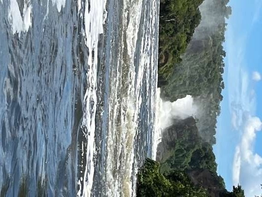
The boat safari on the Victoria Nile between Paraa and the falls base is the centrepiece wildlife experience in the park. From the water, the density of animals on the riverbanks is genuinely remarkable. We saw Nile crocodiles resting on the banks — large, motionless, and at a distance that still made their scale apparent. The crocodiles here are old and well-fed; their size reflects decades of undisturbed living in a protected water system. Hippopotamuses were present in numbers close enough to the boat that the sound of exhalation was audible. Elephants appeared at the bank mid-afternoon, two individuals wading in the shallower margins while the rest of the herd grazed on the floodplain behind.
We left the lodge before 6 am for the game drive, early enough to catch the sunrise over the savanna. The acacia trees threw long parallel shadows across the golden grass as the light came up from the east. It is the image that matches the mental model most people carry of African savanna: silhouetted trees, warm light, flat open grassland. In Murchison, that image is real and unhurried — the park is large enough that visitor pressure is spread thinly, and early morning game drive traffic is manageable even in peak season.
From the field
Frequently asked questions
Where is the gorilla permit office in Kabale?
The Uganda Wildlife Authority gorilla permit office is on Makanga Hill in Kabale, directly next to the Green Hills Hotel. It is the official in-country point of sale for Bwindi and Mgahinga gorilla trekking permits. Permits can also be purchased online through the UWA website or through an accredited tour operator — online booking is the recommended approach for international travellers planning ahead.
How far is Kabale from Bwindi Impenetrable National Park?
Distance varies by sector. The Rushaga and Nkuringo sectors in southern Bwindi are 1.5 to 2 hours from Kabale by road. Ruhija in the northeast is approximately 2.5 hours. Buhoma in the north is the farthest at around 3 hours. Roads are largely paved on the main routes but become unpaved and challenging on the final approach to certain trailheads — 4WD is recommended.
What is the best accommodation in Kabale for gorilla trekking?
The Green Hills Hotel is the most convenient mid-range option — it shares Makanga Hill with the UWA permit office, has 24 rooms, a pool, and a restaurant. For budget travellers, Kabale Backpackers (singles from USD 9, run by Uganda Safari Guides Association deputy chair Lilian Kamusime) and Kwanzi Hostel (singles from USD 5, with a rooftop restaurant and Lake Bunyonyi canoe trip arrangements) are both reliable options with distinct characters.
When is the best time to visit Kabale and southwest Uganda?
The dry seasons — June to September and December to February — offer the firmest trails and best overall trekking conditions. The low season months of April, May, and November bring wetter conditions but reduced permit prices (USD 450 instead of USD 800) and fewer visitors. Kabale's high elevation keeps temperatures moderate year-round; nights are cool in all seasons and can be cold enough for a fleece even in the dry months.
Is Lake Bunyonyi worth visiting from Kabale?
Yes — it is around 30 minutes from Kabale and offers a genuinely different experience from the gorilla trekking circuit. The lake has 29 islands, is considered safe for swimming (low bilharzia risk, no crocodiles), and has several island lodges and community guesthouses accessible by dugout canoe. Bwama Island carries the remains of the leprosy hospital founded by Leonard Sharp in 1921 — the most historically layered site on the lake. A half-day or full day there before or after trekking is time well spent.