Overview
On the road north from Butiru toward Murchison Falls National Park in October 2024, the journey itself offered an immediate lesson in Ugandan logistics. A minibus appeared ahead, moving steadily in the same direction, carrying a load on its roof that reached roughly twice the vehicle's own height: mattresses, rolled bedding, household goods, all roped into a tower that should by any structural reasoning have toppled at the first bend. It did not. The driver was entirely unbothered. Mark Suer photographed it from the passenger seat, the GPS recording coordinates that place the image at 1.9624°N, 31.7122°E on the Murchison route — one of eight GPS-verified photographs taken during this 3-day visit in October 2024. It is, as Suer noted at the time, a genuinely strange image. But it is also, unmistakably, typical Uganda: a country where practicality and ingenuity fill every gap that formal infrastructure leaves open.
The road ahead was good tarmac, open savannah on either side, and somewhere in the distance the Victoria Nile was flowing northwest toward Lake Albert. That river — and the boat safari that follows it from Paraa to the base of Murchison Falls — is the reason most visitors make the journey north.
Murchison Falls National Park: Orientation
Murchison Falls National Park is Uganda's largest national park, covering approximately 3,840 square kilometres of savannah, woodland, and riverine forest along the Victoria Nile in northwestern Uganda. It lies roughly six hours north of Kampala by road, depending on conditions — the journey passes through Masindi before descending to the Nile floodplain. The park takes its name from the point where the entire flow of the Victoria Nile is forced through a gap just seven metres wide, creating a waterfall of extraordinary power.
The park is divided by the Nile into two distinct zones. The northern bank, reached by ferry at Paraa, holds the classic savannah game-viewing terrain: open grassland, scattered acacia and fig trees, and concentrations of elephant, giraffe, buffalo, hartebeest, and Uganda kob. The southern bank is more wooded and less-visited, offering a different ecological character.
For most visitors, the itinerary combines a game drive on the northern bank with a boat safari on the Nile — the two activities are complementary, covering different habitats and different suites of species. The boat safari is by most accounts the more reliable of the two for close wildlife encounters, because the animals come to the river to drink and the boat can approach at water level.
The Victoria Nile Boat Safari
The boat departs from Paraa and travels upstream for approximately two hours, following the Nile to the base of Murchison Falls. It is a slow journey by design: the pace allows time to scan both banks, and the wildlife does not require effort to find.
Nile crocodiles are the most immediately visible large animals. They are present in large numbers along this stretch of the Nile — some resting on sandbanks in full sun, others partially submerged at the water's edge, and occasionally one slipping silently into the river as the boat approaches. During the October 2024 boat safari, crocodiles were sighted repeatedly from well before the falls all the way back to Paraa. Even at the distances the boat maintained — close enough for photography, far enough for safety — the size of the largest animals was striking. Nile crocodiles are among the largest living reptiles; the adults encountered on this river are substantially bigger than any crocodilian species found outside Africa, and their speed entering the water, from what appears to be a position of complete repose, is a reminder that they are highly functional predators rather than decorative features of the landscape.
Hippopotamuses are present throughout the river in large pods. They are most active at dusk and dawn, but during the day they cluster in the shallower reaches, with eyes, ears, and the tops of their backs visible above the surface. The boat passes close enough to hear the low exhalations that hippos make periodically, and to observe the social dynamics within pods — younger animals jostling, adults maintaining space with slow, deliberate movements.
Elephants regularly come to the river to drink and bathe, and encounters from the water are among the best wildlife observations the park offers. On the October 2024 trip, a large bull elephant was sighted feeding on riverbank vegetation, photographed at close range from the boat at GPS coordinates 2.2701°N, 31.6649°E. The angle from the water — looking slightly upward at an animal standing on a bank — produces a different sense of scale than any land-based encounter. What appeared from a distance as a large animal resolves, close, into something enormous: the musculature of the shoulders, the mass of the tusks, the particular unhurriedness with which the animal moved through the vegetation.
Birds are abundant throughout the journey. The African fish eagle calls from trees along both banks. Goliath herons stand motionless in the shallows. Pied and malachite kingfishers work the water's edge. For birders, this section of the Victoria Nile is among the best locations in Uganda to observe the shoebill stork — a species that favours the papyrus and swamp habitats fringing the Nile. Sightings are not guaranteed but are reported frequently on the boat safari route, particularly in the morning when the light is good.
The Falls Themselves
The boat arrives at the base of Murchison Falls after approximately two hours of travel upriver. The approach is gradual: the sound of the falls becomes audible well before the falls themselves come into sight, and the river begins to roughen as the current that creates the falls is felt downstream.
At the base, the full force of the Nile's flow through a seven-metre gap becomes immediately apparent. The water arrives compressed, then expands into a turbulent basin of white and green, throwing spray that reaches the boat and beyond. The noise is substantial — not a background roar but a physical pressure on the ear. The GPS coordinates 2.2751°N, 31.6762°E place the photographs taken here precisely at the falls' base. Standing on the boat looking up at the compressed column of water, the scale of what the Nile carries — the drainage of Lake Victoria, of the Great Lakes region, funnelled to this single point — becomes viscerally comprehensible in a way that no map or statistic communicates.
The boat typically holds position at the base for fifteen to twenty minutes before turning to begin the downstream return. The return journey covers the same water but in faster time, with the animals often in different positions relative to the earlier upstream passage — giving a second set of sighting opportunities without repetition.
Game Drives: The Northern Bank
The northern bank of the Nile offers classic savannah conditions for game driving. The vegetation is open enough that animals are visible at distance, and the concentration of large herbivores — elephant, buffalo, giraffe, Uganda kob, oribi, hartebeest — sustains the predator populations that make the park interesting. Lions are present on the northern bank and are regularly encountered on early morning drives, though sightings cannot be guaranteed.
The October 2024 game drive produced an elephant encounter that remains one of the clearest wildlife memories from that trip. A large bull was moving through medium-height grassland at GPS coordinates 2.2853°N, 31.5099°E, crossing the track at no great distance from the vehicle. The width of the animal across the shoulders, the arc of the tusks, the complete indifference it showed to the vehicle — these details register differently in person than in any photograph. The herd was visible in the middle distance; this animal was clearly a solitary male, moving at its own pace toward the herd's location.
Early morning departures — before six o'clock where the lodge permits — produce the best conditions for both game drives and the boat safari. The air is cool, the light is directional and photogenic, and the animals are active before the heat of mid-morning changes their behaviour. Mark Suer photographed the savannah sunrise at GPS coordinates 2.3703°N, 31.5493°E on the October 2024 morning game drive — the sky in multiple shades of orange behind silhouetted acacia and palm trees, the kind of image that justifies departing the lodge in darkness.
Practical Information for Visitors
Getting there. The most common route from Kampala is north through Masindi to Paraa, a total of approximately 305 kilometres. The road to Masindi is good tarmac; the section from Masindi to Paraa is unpaved for much of its length and requires a vehicle with reasonable ground clearance. A 4WD is strongly recommended in the wet season. Journey time from Kampala is typically five to seven hours.
Alternatively, some visitors approach from the west via Fort Portal and Hoima, which adds distance but passes through different scenery. From the east, the route through Gulu is less commonly used but is entirely feasible.
Seasons and conditions. The park is open year-round. Dry season conditions — December to February and June to July — produce firmer tracks, less mosquito activity, and easier wildlife visibility in shorter vegetation. The wet seasons (March to May and October to November) can make some tracks impassable without a 4WD and produce significantly more mosquitoes. The vegetation is denser and greener in the wet season, which some visitors prefer visually.
The October 2024 visit was made in the early weeks of the short wet season. Track conditions on the northern bank were still manageable, the vegetation had greened substantially, and the afternoon thunderstorms — impressive in themselves — had not yet damaged the major routes.
Boat safari booking. Boat safaris on the Victoria Nile depart from Paraa at scheduled times each day. They can be booked through the park gate or through any lodge within the park. The morning departure is consistently preferred over the afternoon for light quality and animal activity.
Entry fees and permits. Foreign nationals pay national park entry fees set by the Uganda Wildlife Authority (UWA). These fees are subject to periodic revision; current rates should be confirmed with UWA or your accommodation before travel. The park entry fee is separate from any lodge accommodation cost.
Accommodation. Lodges within the park range from the well-established Paraa Safari Lodge on the northern bank to smaller camp-style properties on the southern bank. Lodges outside the park boundary in the Masindi corridor are generally less expensive. The quality and character of accommodation varies significantly between properties; booking in advance for peak-season visits (July–August, December–January) is recommended.
Kabale and Southwest Uganda: The Other Classic Circuit
For visitors planning a longer Uganda itinerary, Kabale anchors the southwestern circuit in the same way that Murchison Falls anchors the north. The two are not conveniently combined in a single trip — the distance between them is over 500 kilometres by road — but together they represent the two landscapes that most define Uganda's tourism offer: savannah wildlife in the north, mountain forest and gorilla trekking in the southwest.
Kabale is a town at roughly 1,900 metres elevation in the hills near the Rwanda border. It serves as the practical base for visits to Lake Bunyonyi, 8 kilometres to the west, and as a staging point for the road to Bwindi Impenetrable National Park. Accommodation in Kabale ranges from basic guesthouses to mid-range hotels; several properties include gorilla trekking coordination services as part of their offering.
Gorilla Trekking: What the Briefing Contains
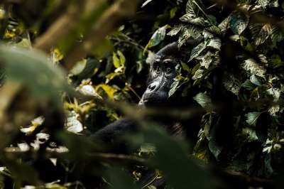
The mountain gorilla population of Uganda numbered approximately 459 individuals in the 2018–2020 census period. This figure reflects a recovery from the critically low numbers recorded in earlier decades — a recovery directly attributable to sustained conservation investment, the habituation programme that makes trekking possible, and the income generated by trekking permits that funds both conservation and community development.
Gorilla trekking is conducted from several sectors of Bwindi Impenetrable National Park: Buhoma in the north, Ruhija in the east, Rushaga and Nkuringo in the south. Each sector has habituated gorilla families allocated to daily trekking groups. Permit numbers are strictly controlled — eight permits per gorilla family per day — which limits both the impact on the gorillas and the availability of permits for visitors.
The January 2026 trekking visit documented in this briefing was conducted from the Buhoma sector. Two rangers accompanied the trekking group — both armed, standard practice for safety in the forest — along with a guide. The ranger presence during the forest approach, in this account, was initially unexpected but entirely unremarkable in practice. The terrain at Bwindi is steep and the vegetation dense enough that a ranger with a machete for cutting is useful as well as protective. By the time the group reached the gorillas, the rangers had faded into the supporting cast; the animals themselves commanded all attention.
Permit costs. Standard season permits for gorilla trekking are priced at USD 800 per person (UWA 2026 rate — verify current rates before booking). Low-season permits — available during April, May, and November — are priced at USD 450, though pricing has been revised periodically. The permit price includes the one-hour time limit with the gorilla family and the services of the guide and rangers.
When to visit southwest Uganda. The rains in southwest Uganda follow a bimodal pattern, with long rains from March to May and shorter rains in October to November. The dry seasons — June to September and December to February — are generally preferred for trekking conditions, as wet season paths become slippery and drainage on steep forest slopes can be substantial. The January 2026 trekking visit was made in the early dry season, and trail conditions were good.
That said, the forest is navigable year-round. Wildlife viewing in the southwest is not strongly season-dependent in the way that open-savannah game viewing can be, because the mountain forest maintains its character throughout the year.
Leonard Sharp and Bwama Island
Any account of the Kabale region that touches on its history should include the figure of Leonard Sharp, a Scottish missionary and doctor who established a hospital for leprosy patients on Bwama Island in Lake Bunyonyi in 1921. The island hospital operated for decades, providing care to patients who had been isolated on the island — as was common practice for leprosy treatment at the time — and the physical structures of the original mission remain visible on the island today. Sharp's work on Bwama Island is one of the notable human stories embedded in the landscape of this corner of southwest Uganda, and the island is accessible by canoe or motorboat from the Lake Bunyonyi shore.
Key Facts
Frequently Asked Questions
How long does the Murchison Falls boat safari take?
The standard boat safari from Paraa to the base of Murchison Falls takes approximately two hours in each direction, for a total on-water time of around four hours. The boat holds position at the falls' base for fifteen to twenty minutes before returning. The morning departure, which leaves Paraa at around 8 am, is consistently recommended over the afternoon trip for light quality and animal activity levels.
What animals are most likely to be seen on the Victoria Nile boat safari?
Nile crocodiles and hippopotamuses are almost certain sightings on any boat safari on this stretch of the Nile — both species are present in large numbers. Elephants frequently come to the riverbank to drink and are regularly photographed from the boats. African fish eagles, goliath herons, kingfishers, and various waterfowl are visible throughout. Shoebill stork sightings are reported regularly but are not guaranteed. The bird list for this section of the Nile is extensive and well-documented.
When is the best time to visit Murchison Falls National Park?
The dry seasons — December to February and June to August — offer the most reliable track conditions and are generally preferred for game driving. The vegetation is lower and less dense, making wildlife easier to spot from vehicles. The wet seasons (March to May and October to November) produce a greener landscape and are generally less crowded, but some tracks on the northern bank may require a 4WD. The October 2024 visit documented here was made in the early wet season with manageable conditions.
How do I get from Kampala to Murchison Falls National Park?
The standard route runs north from Kampala through Masindi to Paraa, approximately 305 kilometres. The Kampala–Masindi section is good tarmac; the Masindi–Paraa section is unpaved and requires a vehicle with reasonable ground clearance (4WD recommended in the wet season). Driving time is typically five to seven hours. Organized safari vehicles from Kampala are the most common approach for international visitors; self-drive is possible with an appropriate vehicle. There is no direct public transport to Paraa.
How much does gorilla trekking cost in Uganda, and when are permits cheapest?
Standard season gorilla trekking permits in Uganda cost USD 800 per person (UWA 2026 rate — verify current rates before booking, as these are revised periodically). Low-season permits, historically available in April, May, and November, were priced at USD 450. The permit covers the one-hour encounter with the gorilla family plus the services of guide and rangers. Permits should be booked well in advance for peak months (July–August, December–January), as availability is strictly limited to eight visitors per gorilla family per day.