Overview
Community & Conservation
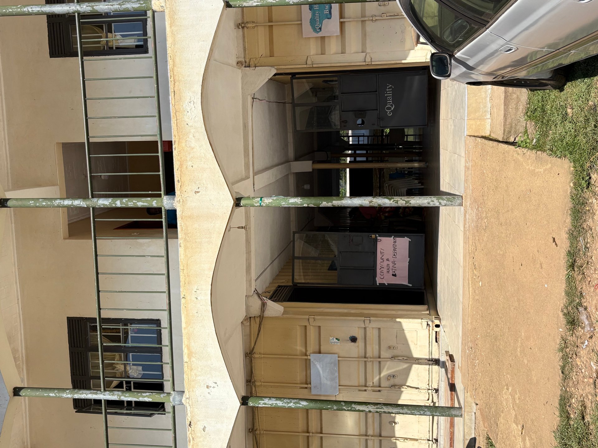
On the grounds of a small hospital in Buhoma, during my visit in January 2026, I found a cluster of buildings assembled from shipping containers and simple block construction. This is the intake ward — the point where adults and children arriving at the facility are first examined and registered. The hospital was founded by a German named Herr Braun, whose name is known to everyone in the village but whose story most passing tourists never encounter. The GPS coordinates of that moment sit at approximately 0.9684°S, 29.6166°E — a few hundred metres from the trailhead where, the same morning, a group of eight visitors would set out to find gorillas.
That proximity is not coincidental. Buhoma is both the oldest gorilla trekking gateway in Uganda and, quietly, one of the most developed examples of park-adjacent community infrastructure in East Africa. The two things grew together: gorilla tourism brought revenue, revenue enabled community investment, and community investment — in healthcare, schools, accommodation — gave residents a tangible stake in the survival of the forest. Understanding Buhoma means understanding how conservation and community development can reinforce rather than oppose each other.
This article is based on four visits to the Bwindi area between October 2024 and May 2026, including time spent in Buhoma village itself rather than only on the trekking trails. The picture of Buhoma that emerges from that experience is richer, and more complicated, than the standard travel narrative of gorillas and forest.
The Hospital and the German Who Founded It
Healthcare access in the Kanungu District is shaped by geography as much as resources. The roads into Buhoma are unpaved and slow; the nearest district hospital is a substantial journey away. The community hospital in Buhoma fills a gap that would otherwise leave residents dependent on transport they often cannot afford or access in time.
The facility founded by Herr Braun operates with the kind of pragmatic architecture that characterises rural healthcare infrastructure across Uganda: permanent block buildings supplemented by shipping container extensions where the need for space outpaced the budget for construction. The container intake ward is functional rather than provisional — it has been in operation long enough to feel permanent, and the staff working within it are clearly experienced at managing a steady flow of patients from the surrounding villages.
What the container ward represents is a design philosophy common to effective direct-aid projects in Uganda: work with available resources, add capacity as funding permits, and keep the institution running rather than waiting for ideal conditions. It is modest, and it works. For a parent carrying a sick child from a village an hour's walk away, the container building at the end of that walk is not a compromise — it is a functioning medical facility where help is available.
[QUOTE: staff member or community leader on the hospital's role in the community — collect on next visit to Buhoma]
Healthcare and conservation: an underappreciated link
The connection between community healthcare and wildlife conservation is well established in conservation biology but rarely discussed in travel writing. Bwindi Impenetrable National Park covers 331 square kilometres of montane rainforest. The communities living on its edges — in Buhoma, Ruhija, Rushaga, and Nkuringo — number tens of thousands of people. For park management to succeed, these residents need credible reasons not to encroach on the forest for farming, firewood, or poaching.
Revenue-sharing from gorilla trekking permits is the most direct mechanism: a proportion of the permit fees paid by visitors flows to community development funds that finance exactly the kind of projects visible in Buhoma — healthcare buildings, school infrastructure, roads. The Uganda Wildlife Authority administers this revenue-sharing structure under the framework that governs park management in Uganda.
When a community has a hospital, a school, and reliable income from tourism, the calculus of encroachment changes. The forest is more valuable standing than cleared, not in the abstract language of biodiversity, but in the concrete language of next month's medical bills. That is the pragmatic foundation of what conservation practitioners call the community-based conservation model, and Buhoma is one of its clearest demonstrations in Uganda.
Uganda's National Parks: Scale and Diversity
Uganda manages ten national parks under the authority of the Uganda Wildlife Authority (UWA), established in 1996 from the merger of the Uganda Game Department and Uganda National Parks. The parks range from the equatorial rainforests of Bwindi and Kibale in the southwest to the semi-arid savanna of Kidepo Valley in the far northeast, a distance of over 700 kilometres. Each park occupies a distinct ecological zone and harbours wildlife assemblages that differ substantially from one another.
The diversity is not accidental — it reflects Uganda's position at the intersection of four major African biogeographic zones: the Eastern Rift, the Congo Basin forests, the East African savanna, and the Albertine Rift highlands. No other country of comparable size contains such a range of ecosystems within its borders, a fact that the Uganda Tourism Board has promoted under the phrase "gifted by nature" since the 1990s.
The southwestern parks: forest and primates
The southwestern cluster — Bwindi Impenetrable, Mgahinga Gorilla, and Kibale — forms the core of Uganda's primate tourism product. Bwindi holds the largest single population of mountain gorillas on earth: 459 individuals were recorded in the 2018–2020 census, distributed across more than 50 family groups of which approximately 20 are habituated for visitor contact. The park shares the Virunga Conservation Area with parks in Rwanda and the Democratic Republic of Congo, forming a transboundary protected landscape managed under the International Gorilla Conservation Programme.
Kibale National Park, 180 kilometres north of Bwindi, holds what is considered the highest density of primates of any forest in Africa. Thirteen primate species have been recorded there, including the largest habituated chimpanzee population in Uganda. The Kanyanchu chimp trekking experience at Kibale is frequently cited alongside gorilla trekking in Bwindi as one of East Africa's defining wildlife encounters.
Mgahinga Gorilla National Park is the smallest of Uganda's national parks at 33.7 square kilometres, sitting at the base of the Virunga volcanoes on the borders with Rwanda and the DRC. It protects the northern slopes of three volcanoes — Muhavura, Gahinga, and Sabyinyo — and offers both gorilla trekking and golden monkey tracking, the latter a species unique to the Virunga highlands.
The western parks: savanna and the Albertine Rift
Queen Elizabeth National Park covers 1,978 square kilometres of the Albertine Rift valley between Lake Edward and Lake George, bisected by the Kazinga Channel. It holds one of Africa's most diverse large-mammal assemblages: elephants, hippos, lions (including the tree-climbing lions of the Ishasha sector, a genetically distinct population), buffalo, leopards, and over 600 recorded bird species. The boat cruise on the Kazinga Channel is one of Uganda's most reliable wildlife viewing experiences — hippo density on the channel is among the highest anywhere in Africa.
Murchison Falls National Park, at 3,840 square kilometres, is the largest of Uganda's parks. The Victoria Nile cuts through it from east to west, dropping 45 metres through a seven-metre-wide cleft in the rock at Murchison Falls before spreading into a broad delta where it enters Lake Albert. The boat safari from Paraa to the base of the falls — passing crocodiles, hippos, elephants drinking at the bank, and in October 2024, three Nile crocodiles that I watched from the boat at close range — remains one of the most densely wildlife-populated river corridors in Uganda.
Rwenzori Mountains National Park protects the Rwenzori range, known historically as the Mountains of the Moon, which form the border between Uganda and the DRC. The highest peaks — Margherita at 5,109 metres — are permanently glaciated, though the glaciers have retreated significantly over the past century. The park is a UNESCO World Heritage Site and hosts the Rwenzori Mountaineering Services and several specialist operators who manage multi-day trekking circuits through the afroalpine zone.
The northern parks: savanna wilderness
Kidepo Valley National Park in the Karamoja region of northeast Uganda is consistently cited by wildlife specialists as one of the most unspoiled savanna parks in Africa. Its remoteness — a seven-to-nine-hour drive from Kampala on roads that have improved substantially since 2018 but remain demanding — means visitor numbers remain low relative to its wildlife density. The park harbours species absent from Uganda's other parks, including cheetah, striped hyena, and caracal. The Apoka Safari Lodge and Kidepo Savannah Lodge serve as the primary accommodation, both within or adjacent to the park.
Lake Mburo National Park, 240 kilometres southwest of Kampala, is the most accessible of Uganda's national parks by road and offers something none of the others do: walking safaris without the accompaniment of an armed escort are permitted in designated zones, a rarity in East African parks. The park is notable for zebra, impala, and eland populations, as well as the highest density of hippos in Uganda in proportion to water surface area.
The Community Tourism Infrastructure Around Bwindi
Buhoma's community tourism infrastructure is the product of over 25 years of deliberate development, anchored initially by the Buhoma Community Rest Camp — established in the early 1990s and one of the first community-owned lodges in Uganda — and expanded through organisations including the Uganda Community Tourism Association (UCOTA), which supports similar enterprises across the country.
The Bwindi Mgahinga Conservation Trust and the Nkuringo Conservation and Development Foundation operate in the southern sectors of the park, channelling conservation revenues into community development programmes. The Institute of Tropical Forest Conservation, based at Ruhija, provides scientific research support for park management and contributes ecological monitoring data that informs gorilla population assessments.
The Bwindi Batwa Development Association represents the Batwa — the forest-dwelling people who were displaced when Bwindi was gazetted as a national park in 1991. The Batwa Cultural Trail, which passes through Buhoma, is one of the mechanisms through which former forest residents generate income from tourism while maintaining a connection to their heritage. It is an imperfect arrangement — the dispossession of the Batwa from their ancestral land remains a significant and unresolved human rights issue — but the trail provides context that most gorilla trekking itineraries omit entirely.
The Buhoma Community Walk
The Buhoma Community Walk is a structured half-day experience that takes visitors through the village, visiting a traditional healer, a local farmer, the craft cooperative, and often the school. It is operated by the community itself, and guides are village residents trained through UCOTA programmes. The walk does not avoid the harder realities — land pressure, the Batwa situation, agricultural encroachment debates — and that directness is part of what makes it valuable.
During my visits to Buhoma, I consistently found that the community walk context changed the gorilla trekking experience that followed. The forest is not an abstract conservation zone when you have met the people who live on its edge, understand the economic pressures they face, and have seen the hospital that depends on tourism revenue to stay operational.
The Broader Conservation Ecosystem
Bwindi and Buhoma do not exist in isolation. The park sits within a transboundary conservation framework that connects it to the Virunga National Park in the DRC and the Volcanoes National Park in Rwanda, the latter being the base for the Karisimbi and Sabyinyo gorilla families made internationally famous by Dian Fossey's research in the 1970s. The Dian Fossey Gorilla Fund International continues active research programmes across the range, contributing to the census methodology that produced the 2018–2020 population count.
The German conservation NGO Berggorilla- und Regenwalddirekthilfe e.V. (Mountain Gorilla and Rainforest Direct Aid) has operated in the Bwindi ecosystem for decades, funding infrastructure projects — including, historically, contributions to community health facilities in the park-adjacent villages. The connection between this organisation's name and the hospital in Buhoma founded by Herr Braun deserves further research; it represents exactly the kind of local history that does not appear in standard travel guides.
The African Wildlife Foundation maintains conservation and community development programmes across the Bwindi landscape, focusing on land-use planning and community enterprise development. Wildplaces Africa, operator of the Semliki Safari Lodge in western Uganda since 1996, represents the model of private conservation enterprise that complements the community structures in Buhoma — different approach, complementary function.
Gorilla permit revenue and what it finances
The USD 800 gorilla trekking permit is not simply a fee for an experience. It is a conservation financing instrument. UWA distributes a portion of permit revenue directly to the communities surrounding Bwindi through the Community Revenue Sharing Programme. Since the programme's inception, these distributions have funded construction of health centres, classroom blocks, water supply systems, and access roads in the villages that otherwise bear the costs of living adjacent to a protected area — reduced agricultural land, restrictions on forest access, crop raiding by elephants and other wildlife.
The precise amounts vary by year and are published in UWA annual reports. The principle is fixed: gorilla tourism must generate visible community benefit, or the conservation case for the park collapses from the ground up. In Buhoma, that principle is visible in the hospital, in the school buildings, and in the container ward where, on a January morning in 2026, the first patients of the day were already waiting.
Frequently asked questions
What is Buhoma and where is it?
Buhoma is a village on the northwestern edge of Bwindi Impenetrable National Park in southwest Uganda, in the Kanungu District. It sits at roughly 1,500 metres above sea level and is the oldest established entry point for gorilla trekking in Bwindi. The nearest significant town is Kihihi, approximately 35 kilometres north. Buhoma is also the location of a community hospital and the headquarters of Buhoma Community Rest Camp, one of Uganda's earliest community-owned tourism enterprises.
How many national parks does Uganda have?
Uganda has ten national parks managed by the Uganda Wildlife Authority: Bwindi Impenetrable, Mgahinga Gorilla, Queen Elizabeth, Kibale, Rwenzori Mountains, Semuliki, Murchison Falls, Kidepo Valley, Lake Mburo, and Mount Elgon. These are supplemented by a network of wildlife reserves, forest reserves, and community wildlife areas. The parks cover a combined area of roughly 20,000 square kilometres and represent some of the most biodiverse protected land on the African continent.
What community tourism exists in Buhoma?
Buhoma has one of Uganda's most developed community tourism ecosystems. The Buhoma Community Rest Camp was among the first community-owned accommodation facilities in Uganda. The Uganda Community Tourism Association supports Buhoma as a model site for community-based ecotourism. Activities include the Buhoma Community Walk, village visits, craft markets, and cultural performances — all generating income for residents rather than external operators.
Is it safe to visit Bwindi Impenetrable National Park?
Bwindi Impenetrable National Park is considered safe for visitors travelling on organised gorilla trekking permits issued by the Uganda Wildlife Authority. All trekking groups are accompanied by trained UWA guides and armed rangers. The Buhoma sector has operated without significant security incidents for over two decades. Visitors should follow standard precautions for remote travel in East Africa: adequate insurance, yellow fever vaccination, and permit booking through licensed operators.
What is the Uganda Community Tourism Association?
The Uganda Community Tourism Association (UCOTA) is a membership organisation that supports and promotes community-based tourism enterprises across Uganda. It provides capacity-building, marketing support, and quality standards for community lodges, cultural tourism programmes, and community-owned conservation initiatives. UCOTA has been instrumental in formalising the community tourism sector in areas like Buhoma, Kibale, and the Rwenzori foothills, ensuring that tourism revenue reaches local households rather than only commercial operators.