Overview
Western Uganda is one of the most wildlife-rich, scenically extraordinary regions in the country. According to the Uganda Statistical Abstract 2014, the Western region contains 42 percent of Uganda's tourist attractions: lakes, hot springs, monuments, and national parks that draw visitors from every continent.
This article draws on multiple on-site visits: twelve days at Murchison Falls in October 2024, eleven days in the Bwindi and Buhoma area in January 2026, and further return visits through June 2026. All photographs are GPS-verified originals taken on location.
A Region Built Around Its Wilderness
Western Uganda's 42 percent share of the country's tourist attractions is not explained by national parks alone. The figure encompasses the Rwenzori Mountains — Africa's third-highest range and one of its most biologically distinctive — along with Lake Edward, Lake George, the Kazinga Channel, dozens of crater lakes in the Bunyaruguru and Ndali fields, thermal springs at Sempaya in Semuliki National Park, and several cultural and archaeological sites. What the Western region offers is an unusual compression of distinct ecosystems within a relatively short distance.
Uganda's total land area is 241,551 square kilometres — compact by African standards. The western corridor, running roughly 400 kilometres from Murchison Falls in the north to Bwindi in the south, passes through semi-arid savanna, tropical moist forest, high-altitude moorland, montane rainforest, and equatorial wetland. No single day of driving in Uganda produces the same landscape twice. That ecological range, within a country you can cross in a day, is what sets the Western region apart.
The same region records a poverty headcount of 10 percent, with approximately 1.10 million people living below the poverty line. Tourism does not erase that. The question of who captures tourism revenue — and how much reaches the households adjacent to park boundaries — remains structural, ongoing, and not adequately answered by gate fee statistics.
Uganda's National Park System: The Numbers
Uganda administers twelve national parks and three game reserves, according to the Statistical Abstract 2014 published by the Uganda Bureau of Statistics. The park network spans all five of the country's ecological zones and is managed by the Uganda Wildlife Authority, which maintains entry registers, issues permits, and deploys rangers across all sites.
The visitor trend heading into the mid-2010s showed sustained growth. Total national park visitors rose from 151,818 in 2009 to 182,149 in 2012 and 213,950 in 2013 — an increase of 41 percent over four years, and 17.5 percent in the final year alone. These figures represent paid admissions logged at entry gates; they do not include informal visitors or those entering through community zones.
Foreign non-residents accounted for 47 percent of all park visitors in 2013. East African Community nationals — primarily from Kenya, Tanzania, and Rwanda — represented 24 percent. The remaining 29 percent were Ugandan citizens. This composition shapes the revenue structure of the park system, since foreign non-residents pay substantially higher entry and permit fees than residents. The gorilla trekking permit, charged exclusively at the foreign non-resident rate for international visitors, is the single highest-value transaction in the entire system.
Seasonality
Visitor distribution is heavily seasonal. The third quarter — July through September — accounts for 39.45 percent of all annual park visits according to 2013 UWA data, driven by Uganda's main dry season. Vegetation thins, game tracks become accessible, and wildlife concentrates around permanent water sources. Visibility across open savanna, for game drives and river safaris alike, reaches its peak during this window.
The first quarter — January through March — is the second most active period, catching the short dry season that follows the November–December rains. Both the October short rains and the March–May long rains reduce park visitation but rarely close parks entirely. October visits, in particular, offer a trade-off that many repeat visitors prefer: fewer people, greener landscapes, and more responsive wildlife, at the cost of occasional track closures on the north bank at Murchison.
Murchison Falls: Uganda's Most Visited Park
Murchison Falls National Park received approximately 70,799 visitors in 2013 — 33 percent of all national park visits in Uganda that year, the largest share of any single park in the country. Queen Elizabeth National Park followed at 32 percent. The concentration of visitors in these two parks reflects both their accessibility from Kampala and the breadth of their wildlife offering.
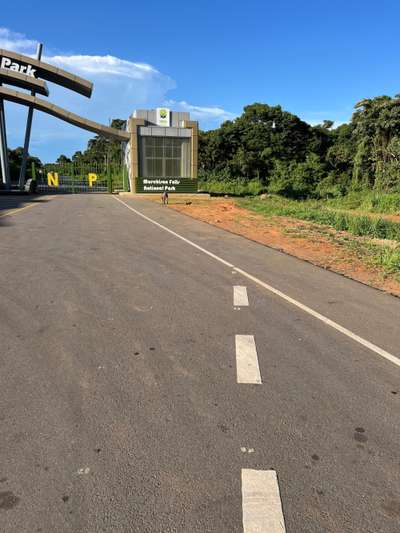
The entrance to Murchison Falls — GPS: 1.4462°N, 32.0787°E, photographed October 17, 2024 — does not resemble what most visitors expect of a remote national park. The approach road is freshly asphalted, wide, and clearly marked. A new visitor centre sits at the gate, functional and well-staffed. The road surface itself is not a patched upgrade to an older track but a purpose-built corridor. The investment is visible in the detail: white lane markings, proper drainage channels, consistent surfacing for several kilometres in both directions.
That infrastructure matters for visitor numbers. Murchison Falls is approximately 300 kilometres from Kampala — four to five hours by road under good conditions. The park's north bank game-drive circuits, the boat safari upstream to the falls, and the launch site at Paraa all depend on accessible roads. An all-weather approach removes the wet-season barrier that historically made self-drive visits unpredictable and rendered some circuits effectively seasonal.
The Park's Scale and Wildlife
Murchison Falls covers approximately 3,840 square kilometres in northwestern Uganda, bisected by the Victoria Nile. The park's defining feature is the point where the entire river — carrying the full drainage volume of Lake Victoria — is compressed through a seven-metre-wide gorge before dropping roughly 43 metres. The spray column is visible from distance; the sound carries further still.
The north bank savanna supports the classic East African mix: Rothschild's giraffe in significant numbers, Uganda's largest elephant population, lion, buffalo, and Uganda kob. The Victoria Nile corridor holds Nile crocodile and hippo at densities among the highest in the region. The boat safari from Paraa upstream to the base of the falls — approximately 17 kilometres each way, taking around three hours — provides reliable close-range wildlife encounters regardless of season. On the October 2024 visit, the first crocodile appeared within fifteen minutes of departure; hippo pods required the boat to navigate around them rather than waiting for clearance.
For a detailed account of the boat safari itself, including departure times and what to expect at the falls, see the western Uganda route guide.
Bwindi and the Gorilla Trekking Circuit
Bwindi Impenetrable National Park accounted for 10 percent of Uganda's national park visitors in 2013 — approximately 21,695 people — despite being the park that commands the highest permit price and the strongest international name recognition. The constraint is deliberate: each habituated gorilla family receives one group of eight visitors per day, across four sectors, capping total daily trekking numbers at a fraction of what the site could accommodate. The permit scarcity is what preserves the experience.
Bwindi sits at elevations between 1,160 and 2,607 metres above sea level in the far southwest of Uganda, in afromontane rainforest that has remained largely intact since the Pleistocene. The park is home to roughly 60 percent of the world's remaining mountain gorillas, according to Uganda's National Status of the Environment Report 2024. The global gorilla population is small enough that a single park holding 60 percent of it is a conservation fact with no real precedent in wildlife management.
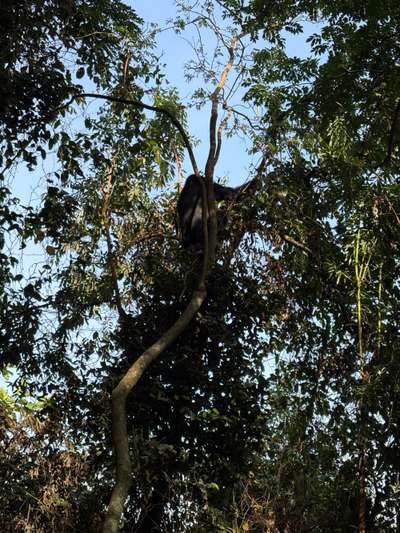
During gorilla trekking in January 2026, our group reached the first family after roughly one hour of walking from the Buhoma trailhead. The first animal encountered was a male sitting in a tree, eating leaves — calm, unhurried, occupying the canopy in the way that a person might sit in a chair. The ranger indicated where to stop. The gorilla continued feeding. The photograph above was taken at GPS: 0.9735°S, 29.6281°E. There is no stock photography involved.
The gorilla trekking permit is currently USD 800 per person for foreign non-residents. East African Community residents pay a lower rate. The permit must be booked in advance through the UWA online portal or a licensed tour operator; last-minute availability exists but is unreliable for the Buhoma sector, where permit demand consistently exceeds supply.
The Four Sectors
Bwindi's trekking is divided across four sectors: Buhoma (northwest), Ruhija (east), Rushaga (south), and Nkuringo (southwest). Buhoma is the oldest and most developed, with the widest range of accommodation and the park's longest operating history. Ruhija sits at the highest altitude and offers the best birdwatching alongside gorilla encounters. Rushaga has the highest number of habituated families, which means more available permits. Nkuringo involves the most demanding terrain — steep descents that extend trek times significantly.
A detailed sector-by-sector comparison, including permit availability patterns and what each sector offers beyond gorillas, is available in the Bwindi sectors guide. For a full account of what a trekking day actually involves, see gorilla trekking at Bwindi: what the day looks like.
The Communities Within the Conservation Landscape
The children at the edge of the compound in Buhoma are not background detail. They are the context within which the entire conservation and tourism economy operates. The western corridor holds Uganda's largest concentration of wildlife tourism revenue and, simultaneously, more than a million people in poverty. Understanding what tourism means on the ground requires moving between both facts without dissolving either one.
Uganda Wildlife Authority operates a revenue-sharing programme that allocates a portion of park gate fees to communities surrounding national parks. In Bwindi's case, this has funded schools, health centres, and local infrastructure. The Buhoma Community Rest Camp — one of Uganda's first community-owned accommodation enterprises — channels revenue directly to resident families. These are genuine mechanisms, not decorative commitments.
What formal revenue-sharing statistics do not capture is the informal daily economy surrounding each park: the boda-boda drivers ferrying visitors, the shops supplying lodge kitchens, the families providing accommodation to rangers' families. Tourism at Bwindi is more economically diffuse than gate-fee data suggests. The formal figures represent only the portion of the value chain that passes through an official accounting mechanism.
The same applies to vulnerability. Uganda's national data on orphanhood and food insecurity identifies southwestern districts as having lower rates than the north, but the presence of children going hungry within earshot of a premium-priced lodge is a local reality, not a statistical abstraction. Hope on the Road works directly with communities in the Buhoma area; the photographs and observations in this article come from that work, documented on the ground, not assembled from secondary sources. For more on what daily life and community tourism look like in Buhoma specifically, see Buhoma: the community behind Bwindi National Park and community tourism in Buhoma.
From the field
Frequently asked questions
What percentage of Uganda's tourist attractions are in the Western region?
The Western region contains 42 percent of Uganda's tourist attractions, according to the Uganda Statistical Abstract 2014. This includes national parks, lakes, hot springs, and monuments — the combined presence of Murchison Falls, Queen Elizabeth, Kibale, Bwindi, the Rwenzori Mountains, and numerous crater lakes makes the western corridor the most tourism-dense zone in the country.
Which is Uganda's most visited national park?
Murchison Falls National Park has historically been Uganda's most visited national park. According to the Statistical Abstract 2014, it received approximately 70,799 visitors in 2013 — 33 percent of all national park visitors that year. Queen Elizabeth National Park followed at 32 percent. These figures come from entry gate registers maintained by the Uganda Wildlife Authority; they represent 2013 data and current visitor numbers will differ.
When is the best time to visit Uganda's national parks?
Uganda's main dry season — July through September — accounts for approximately 39 percent of annual national park visits according to UWA data. Wildlife is most visible as vegetation is lower and animals concentrate around water. June and October are also strong months based on multiple first-hand visits; October brings shorter rains, which reduce crowds but can restrict access to some game-drive circuits. For gorilla trekking at Bwindi, permits are in demand year-round and the experience is reliable in any season.
How much does gorilla trekking in Uganda cost?
As of 2026, the Uganda Wildlife Authority charges USD 800 per person for a gorilla trekking permit at Bwindi or Mgahinga. The permit covers one hour of contact time with a habituated gorilla family, guided by UWA rangers. East African Community residents pay a lower rate. Permits must be booked in advance — last-minute availability is possible but not reliable for popular sectors like Buhoma. Booking through the UWA directly or a licensed Ugandan tour operator is recommended.
Can you combine Murchison Falls and Bwindi in one trip?
Yes — Murchison Falls sits in northwestern Uganda, Bwindi in the far southwest, roughly 500 kilometres apart by road. A combined itinerary requires at least ten days. Most visitors travel the route Kampala–Murchison–Fort Portal–Bwindi or the reverse, with two to three nights at each park. Adding Kibale National Park for chimpanzee tracking near Fort Portal is efficient and adds the third major primate experience. Charter flights between Pakuba airstrip (Murchison) and Kihihi or Kisoro (Bwindi) are available and cut travel time significantly.