Overview
Uganda holds approximately 44,081 square kilometres of inland water — nearly 18 percent of the country's total area — in the form of lakes, rivers, wetlands, and swamps, according to the Uganda Statistical Abstract. Its equatorial position and bi-annual rainy seasons provide among the most reliable rainfall regimes in sub-Saharan Africa. Yet the question of how that water reaches the people and establishments that need it — including the hotels, lodges, and guesthouses that serve 1.2 million annual tourists — involves infrastructure, distribution, and governance challenges that the raw resource endowment alone does not resolve.
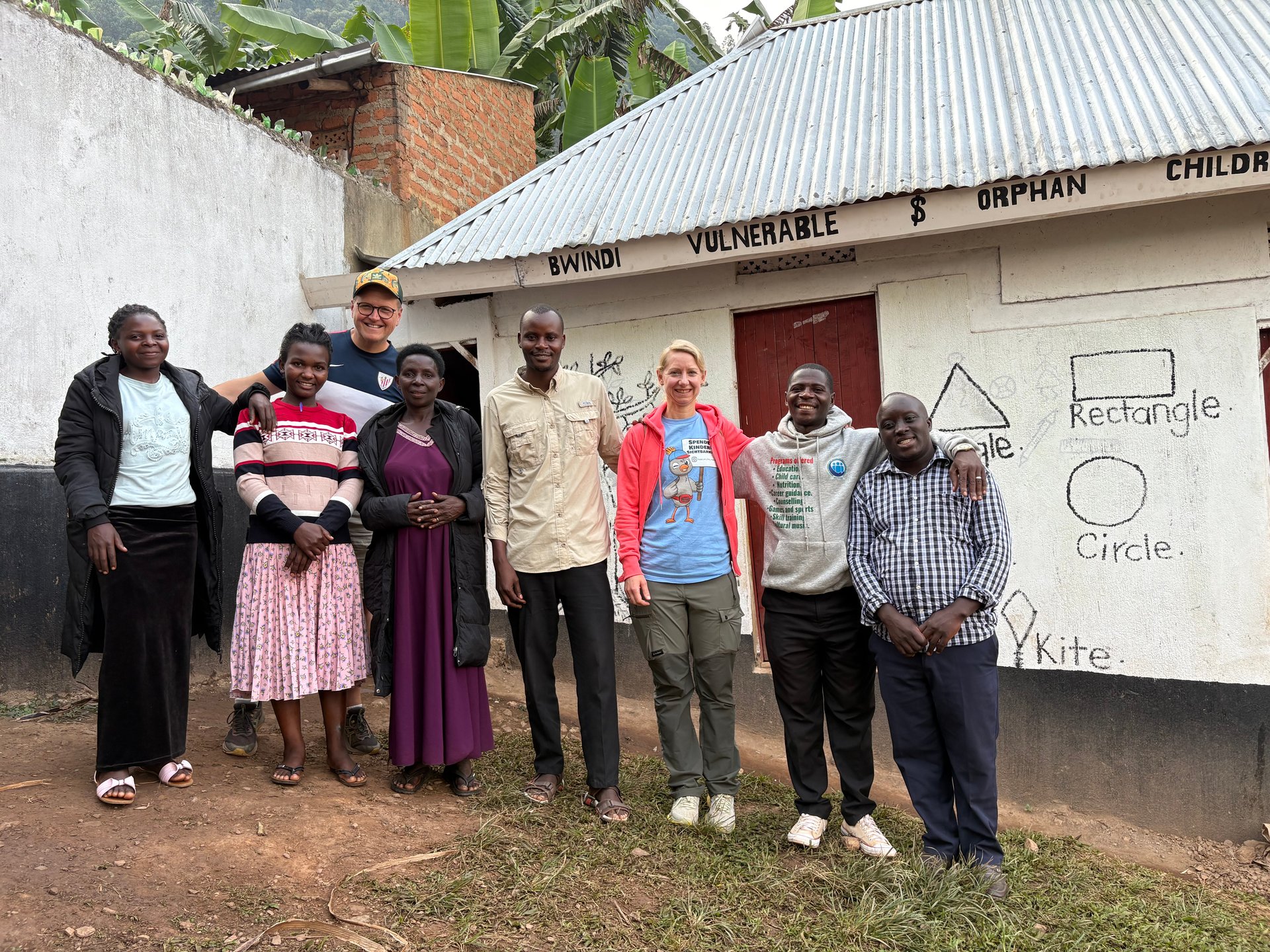
In June 2026 I visited Buhoma in the Kigezi highlands of southwestern Uganda, at GPS coordinates documented as 0.9617°S, 29.6109°E, photographed on 21 June 2026. Three children from the neighbourhood of the local orphanage arrived at the edge of a meal. They were shy, visibly not doing well — their clothes and bearing both carrying the mark of difficult circumstances. We invited them to join us directly. They eventually did. I mention this not as preamble to a separate subject, but because the water question and the human welfare question are the same question in much of Uganda: who has reliable, safe water access, where it comes from, how it is managed, and what role the tourism sector plays in that landscape. During my eleven days in January 2026, my twelve days in October 2024, and my thirteen-day stay in May 2026, I have observed the water infrastructure at lodges and community facilities across western and southwestern Uganda at close range.
This article draws on the 2024 Uganda Water Accounts, published by the Uganda Bureau of Statistics in November 2025, to place hotel and lodge water consumption within Uganda's national water use framework — a framework that has been systematically documented for the first time in this edition. It examines how Uganda's water resources are distributed across sectors, what distinguishes hotel and lodge water use from other categories, and what the data reveals about the relationship between tourism infrastructure and water resource management.
Uganda's Water Resource Base
Uganda's inland water geography is a consequence of its position at the intersection of the East African Rift system and the equatorial plateau. The country's major water bodies — Lake Victoria in the south, Lake Albert and Lake Edward along the western rift, Lake George in the southwest, and Lake Kyoga in the centre — together with the rivers that connect them, constitute one of the most significant freshwater systems in Africa by volume. The Victoria Nile drains Lake Victoria northward into Lake Kyoga and then into Lake Albert before becoming the Albert Nile and crossing into South Sudan.
Surface and groundwater resources in Uganda are jointly documented in the Water Accounts as the country's natural water capital. Surface resources — rivers, lakes, and seasonal wetlands — are the primary source for most water abstractions, including those used by the formal water utility sector, irrigation systems, and industrial users. Groundwater aquifers, accessed through boreholes and protected springs, are critical in areas where surface water distribution is limited or where surface water quality is unreliable.
The country's water resource endowment is substantial relative to its population. What limits water access is not primarily resource availability but the infrastructure required to abstract, treat, store, and distribute water to the locations and populations that need it. Uganda's water accounts are, in part, an accounting of that gap between physical resource and distributed access.
Rainfall and Recharge
Uganda's equatorial position produces two annual rainy seasons across most of the country: the long rains from March to May and the short rains from October to December. Average annual rainfall across the central plateau ranges from approximately 900 to 1,500 millimetres, with the Lake Victoria basin and the western highlands receiving higher totals. The Kigezi highlands around Bwindi — where the lodge and community accommodation concentration relevant to this article is located — receive among the highest rainfall totals in Uganda, typically exceeding 1,200 millimetres annually.
This rainfall pattern is what makes the Kigezi highlands both agriculturally productive (supporting the population density of over 300 persons per square kilometre noted in census data) and reliably watered for the streams and gravity-fed systems that supply many lodges and community facilities in the area. When I visited Bwindi in June 2026 during the short dry season, the highland streams were still running — a characteristic of the area's consistent rainfall and the water-retention properties of the volcanic soils and intact forest cover in and around the park.
Uganda's Water Use Sectors: The 2024 Accounts Framework
The 2024 Uganda Water Accounts, published by UBOS in November 2025, apply the System of Environmental-Economic Accounting for Water (SEEA-Water) framework to Uganda's national water data for the first time in a comprehensive, standardised form. SEEA-Water is the international standard for integrating water resource data into national accounts, allowing water use to be tracked across economic sectors in a way that is comparable to GDP measurement.
The accounts identify the following major water-using sectors in Uganda:
Rainfed crop agriculture is Uganda's dominant water use sector by volume — not because it abstracts large quantities from rivers or boreholes, but because the total evapotranspiration from Uganda's approximately 197,000 square kilometres of agricultural land, driven by rainfall, constitutes the largest single water flux in the national economy. This is a conceptually important distinction: rainfed agriculture uses water but does not compete with other users for abstracted water in the way that irrigation, industry, and urban supply do.
Irrigation agriculture, which involves formal abstraction from water sources for crop production, is a much smaller sector in Uganda than rainfed agriculture — Uganda's favourable rainfall means that extensive irrigation has not historically been necessary for most of the country. However, the drought assessments for districts like Terego (a major refugee-hosting area in the northwest) indicate that climate variability is increasing pressure on rainfed systems, and irrigation's role in Uganda's water accounts is expected to grow.
Livestock represents a significant water use sector, particularly in Uganda's cattle-keeping regions of the west (Ankole) and the drier north and northeast (Karamoja). Water for livestock drinking, washing, and dairy processing comes primarily from rivers, watering holes, and boreholes. In Karamoja — Uganda's most arid district, with population densities below 40 persons per square kilometre — seasonal water scarcity for livestock is a perennial governance challenge.
Hydroelectric power generation accounts for a large water throughput in Uganda's accounts, though much of this is classified as non-consumptive: water passes through turbines and returns to the river system. The Kiira and Nalubaale hydropower stations at Jinja, where the Victoria Nile exits Lake Victoria, together represent significant generation capacity. The planned Tillenga Gas Power Project (80 MW, Bulisa District) and Kingfisher Gas Power Project (53.7 MW, Kikuube District) will add non-hydro generation capacity, reducing the water intensity of Uganda's electricity sector as these projects come online. The Lisimba project adds a further 180 MW. Winch Energy Uganda serves 31 off-grid sites in areas including Bunjako and Lamwo, further diversifying the energy-water nexus at local level.
Household Water Use and Access
Household water use in Uganda spans a spectrum from piped metered supply (primarily in Kampala and major towns, served by the National Water and Sewerage Corporation) to unprotected surface water (rivers and ponds without treatment) at the less-served end. The Water Supply, Sewerage and Waste Management Activities sector in the Water Accounts covers the formal utility infrastructure — treatment plants, distribution networks, and sewerage systems — that serves the piped portion of the population.
Kampala's piped supply reaches a substantial portion of the city's population, though informal settlements in the peri-urban areas often depend on water vendors or shared standpipes rather than direct household connections. Outside Kampala, the National Water and Sewerage Corporation (NWSC) operates in a number of secondary towns. In rural Uganda, water supply typically depends on boreholes drilled by government or NGO programmes, protected springs developed with community management structures, or rainwater harvesting systems. The quality and reliability of these sources vary significantly by location, maintenance history, and seasonal conditions.
Hotels and Accommodation: Water Use in Context
Within the sectoral framework of the 2024 Uganda Water Accounts, hotels and restaurants fall within the broader commercial services category — distinct from household use, industrial use, or agricultural use, but sharing characteristics with all three depending on the establishment type. A large Kampala hotel with a swimming pool, laundry service, and multiple restaurants has an industrial water use profile. A basic community guesthouse in Buhoma has a use profile closer to a household. A safari lodge in a national park may have a complex profile that includes accommodation supply, staff facilities, and on-site food production.
From the field, across fourteen visits to Uganda over twelve days in October 2024, eleven days in January 2026, and thirteen days in May 2026, I have observed water supply arrangements at a range of accommodation types. The patterns are consistent enough to describe with confidence even without aggregate statistical data.
Water Supply at Safari Lodges
High-end safari lodges in Uganda's national park areas typically invest in water infrastructure as a fundamental operational requirement. In Bwindi, lodges at Buhoma draw from highland streams and rivers, with gravity-fed systems where the terrain permits and pump-assisted systems where it does not. Water is stored in elevated tanks that provide pressure for distribution throughout the property. Filtering and treatment — often UV sterilisation for drinking water — are standard at lodges in this category.
The volumes involved are not trivial. A high-end lodge serving fifty guests at international standards — multiple daily showers, laundry, landscaping, kitchen operations, swimming pool — uses water at a rate comparable to a small industrial facility. In a watershed that also supplies community households, smallholder agriculture, and wildlife, this abstraction has a footprint that responsible operators are increasingly required to account for.
[QUOTE: lodge manager or water engineer on the specific source and daily abstraction volume for a Bwindi lodge — to be collected on next visit]
The environmental permit system administered by the National Environment Management Authority (NEMA) requires formal lodges to obtain water abstraction permits and environmental impact assessments for their operations. Whether this requirement is consistently applied and enforced across the full range of accommodation establishments in Uganda's park areas is a governance question that goes beyond the scope of available statistical data, but it is the legal framework within which water use is supposed to be managed.
Water at Budget Guesthouses and Community Lodges
Budget guesthouses and community-run accommodation in Uganda's rural areas operate on a very different water infrastructure basis. In Buhoma and similar communities adjacent to national parks, water supply typically relies on community boreholes, protected springs, or gravity-fed systems developed by NGO programmes. The capacity of these systems is calibrated to household and small commercial use — sufficient for basic accommodation but not for the water-intensive amenities of high-end lodges.
The community accommodation adjacent to Bwindi's Buhoma sector — where I photographed at GPS coordinates 0.9617°S, 29.6109°E on 21 June 2026 — draws from the same local water infrastructure that serves the surrounding households. This shared-resource model creates a direct link between tourism water use and community water access: if the tourism sector expands faster than the infrastructure capacity, the additional draw comes at the expense of household supply. Conversely, tourism revenues that are reinvested in water infrastructure — through community development funds or direct lodge investment — can improve supply for the whole community.
Water Infrastructure for Uganda's Tourism Sector: Gaps and Investments
Uganda's tourism sector contributed approximately USD 979 million in annual revenue as of the Statistical Abstract 2014 period, with 200,000 direct and a further 284,000 indirect and induced employees. This economic mass is directly dependent on water supply chains that in many parts of the country remain fragile — dependent on rainfall, on maintained boreholes and springs, and on distribution systems that were built for smaller populations than those now using them.
The 1,206,334 tourists registered in Uganda in 2013 (according to the Statistical Abstract 2014 — a 0.8 percent increase from 1,196,765 in 2012) each consumed water during their stay. The total accommodation water footprint of Uganda's tourism sector for that year is not available in the published statistical data, but even a conservative estimate of 200 litres per tourist per day of stay (a standard hotel benchmark for mid-range accommodation) implies a significant aggregate abstraction across the country's accommodation stock.
The Hydropower Connection
Uganda's electricity supply — which hotels and lodges depend on for water pumping, treatment, refrigeration, lighting, and HVAC — is predominantly hydropower. The Kiira and Nalubaale power station duo at Jinja on the Nile, the Karuma hydropower project on the Victoria Nile in the north, and the Isimba dam further upstream together constitute the backbone of Uganda's grid. This means that the energy and water sectors are directly coupled: drought years that reduce Lake Victoria's level also reduce hydropower output and increase grid pressure — the same conditions under which tourism accommodation faces elevated water stress.
The planned diversification of Uganda's energy supply through the Tillenga Gas Power Project (80 MW in Bulisa District), the Kingfisher Gas Power Project (53.7 MW in Kikuube District), and the Lisimba project (180 MW) will reduce this coupling over time. Off-grid solar and small hydro systems like those operated by Winch Energy Uganda at 31 sites across Bunjako and Lamwo already provide partial independence from the main grid for remote lodge and community facilities.
The Water Accounts as Planning Tool
The significance of the 2024 Uganda Water Accounts is not simply the data they contain but the planning framework they enable. For the first time, Uganda has a standardised national methodology for tracking water flows across economic sectors — making it possible, in principle, to calculate the water intensity of tourism GDP alongside the water intensity of agricultural GDP, hydropower, or industrial output. This is the kind of analysis that informs water allocation decisions, infrastructure investment priorities, and environmental permit frameworks.
For the tourism sector specifically, the Water Accounts create accountability infrastructure: if water abstraction by accommodation establishments is systematically measured and reported, the sector can be managed as a stakeholder in Uganda's water governance rather than as an invisible user. The gap between having the framework and having the establishment-level data is a gap that UBOS, the Uganda Tourism Board, and NEMA will need to close together.
The 2024 Uganda Water Accounts represent an important methodological step. Whether the hotel-specific data needed to answer the original question — how much water do Uganda's accommodation establishments actually use — will appear in the next edition or the one after remains to be seen. The framework now exists to collect and report it.
Frequently asked questions
How much water do hotels use in Uganda?
Specific per-establishment water consumption data for Uganda's hotel sector are not yet disaggregated in the 2024 Uganda Water Accounts (published November 2025). The accounts document sectoral water use across agriculture, livestock, electricity, households, and industry, but hotel-specific figures require further research. What is established is that rainfed agriculture is Uganda's largest water user by volume, with hotels and restaurants falling within the broader commercial services category.
Where does water come from in Uganda's national parks?
In the Kigezi highlands around Bwindi, lodges and community facilities rely on highland streams, gravity-fed systems, and boreholes. The area receives over 1,200 mm of annual rainfall and the volcanic soils retain water well. In savanna parks — Murchison Falls, Queen Elizabeth, Kidepo — lodges typically draw from rivers, boreholes, or water trucking where direct abstraction is not feasible. Water abstraction at formal lodges requires environmental permits from NEMA under Uganda's environmental regulations.
Is Uganda's water supply safe to drink?
Uganda's formal urban water supply (NWSC in Kampala and major towns) is treated and generally safe from the tap. At rural lodges and guesthouses, tap water should be treated as potentially unsafe for drinking; most lodges provide filtered or bottled drinking water. Travellers in rural Uganda, including park-adjacent areas like Bwindi, should not drink untreated tap or surface water without purification.
What is the main water use sector in Uganda?
According to the 2024 Uganda Water Accounts, rainfed crop agriculture is Uganda's largest water consumer by volume — driven by evapotranspiration across Uganda's ~197,000 km² of agricultural land. Irrigation agriculture, livestock, hydroelectric power generation (Kiira, Nalubaale, Karuma), household consumption, and industrial use each represent additional major categories within the SEEA-Water accounting framework.
Does Uganda have enough water?
Uganda has substantial surface and groundwater resources — approximately 44,081 km² of inland water representing 18 percent of the country's area, plus significant groundwater aquifers. Two annual rainy seasons provide consistent recharge across most of the country. The constraint is not resource availability but distribution infrastructure: urban piped supply reaches a minority of the population, and many rural households depend on boreholes, springs, or surface water of variable quality and reliability.